Included Meals
- Breakfast: 0
- Lunch: 0
- Dinner: 0
Unbeatable Holiday Offers – Save Up to 20% on Your Next Adventure!
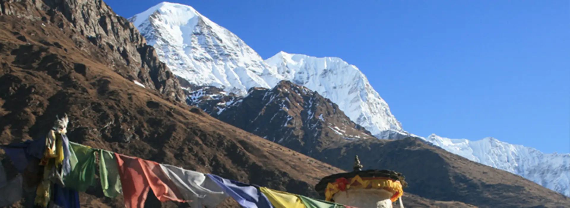
The Ganesh Himal Trek is a 15-day exploration of a quiet, less-traveled part of Nepal. Trekkers hike through remote villages, forested hills, and broad alpine valleys, enjoying uninterrupted views of Ganesh Himal, Langtang Lirung, and Manaslu.
Nestled between the Langtang and Manaslu regions, this area offers some of the best panoramic mountain views in Nepal. With fewer crowds, travelers experience a more intimate and authentic Himalayan trek.
Along the trek, travelers pass through Tamang and Gurung villages where life unfolds at a slower pace than in the cities. Warm hospitality, centuries-old customs, and hand-built stone houses offer insight into high-mountain living.
Trekkers pass terraced farmlands, rhododendron and pine forests, high alpine meadows, and sacred glaciers, observing how culture and nature coexist in these remote regions. Guides share local stories and historical knowledge, enriching the trek beyond the scenic views.
A highlight of the trek is Ganesh Himal Base Camp, situated near the twin sacred lakes, Kalo and Seto Kunda. These serene lakes hold spiritual significance for locals and provide a reflective atmosphere for travelers.
The trail also crosses Pangsang Pass at around 3,850 meters, rewarding trekkers with sweeping 270-degree views of the surrounding Himalayas. With gradual climbs and descents through forests and ridgelines, the trek remains accessible to those with moderate fitness and requires no technical experience.
Trekkers typically walk 5 to 6 hours daily at a comfortable pace, staying in teahouses or occasionally camping in remote areas. Simple meals like dal bhat, noodle soups, and tea fuel the trek, while guides and porters manage logistics and provide stories of the region.
Proper acclimatization near the lakes ensures a safe ascent, with the highest overnight stop around 4,100 meters. The Ganesh Himal Trek offers a combination of wild landscapes, cultural immersion, and quiet mountain trails, ideal for those seeking solitude and authenticity in the Himalayas.
Included Meals
Trip staff
Transport
Accommodation
Trip Grade
Group Size
Your adventure begins with a drive to northern Nepal towards the Ganesh Himal region through the Trishuli River. The road follows green hills and offers distant views of peaks like Ganesh Himal and Manaslu.
After about three hours on the road, you will reach Trishuli Bazaar, a small market. Then, the road gets bumpier and dustier. Continue through Syabrubesi (1,503m), the small town and a gateway to Langtang National Park, where you will stop for a rest. Then, the drive goes through a narrow, twisting mountain road towards Gatlang, a charming Tamang village. You will arrive here by late afternoon, where you will stay the night.
You can explore the village’s traditional stone houses and local lifestyle here. You can also visit the community monastery and learn about the deep Tamang culture of the town. Enjoy a warm meal and settle into a teahouse in Gatlang.
Distance/Duration: ~125 km, 7–8 hours by Jeep or bus.
Starting Altitude: Kathmandu – 1,400 m (4,593 ft).
Ending Altitude: Gatlang – approx. 2,337 m (7,690 ft).
Meals: Lunch en route, Dinner in Gatlang
Accommodation: Teahouse in Gatlang
Time & Distance 6 Hours
The trek begins after breakfast in Gatlang. The trail gently climbs through terraced farmlands into the shady rhododendron and pine forests. Today’s trek will gain significant altitude, over 900m, so walk comfortably and hydrate well to enjoy the day.
As you climb, you will see small Tamang villages with maize, potatoes, and barley fields. The trail goes through many mani walls and fluttering prayer flags. The landscape shifts gradually into a more open sky, wider ridges, and quiet trails with mossy stones. You can pause at a viewpoint for glimpses of mountains and a break.
Continue through the dense woods and a few streams to reach Somdang, a border between Dhading and Rasuwa. Since Somdang was a mining outpost, you can spot a 1.4 km-long old mine tunnel. Though the area is quiet now, decades ago, people used to extract minerals like zinc, copper, and even rubies here.
You will arrive in Somdang by late afternoon and settle into a teahouse for the night. The air is cooler, and the valley is silent. Chat with your guide, explore the village, or rest early.
Distance/Duration: ~10–12 km, 6–7 hours trekking
Starting Altitude: Gatlang – 2,337 m (7,690 ft)
Ending Altitude: Somdang – 3,271 m (10,760 ft)
Meals: Breakfast, Lunch, Dinner
Accommodation: Teahouse in Somdang
Today’s trek is shorter but includes a steady climb into a high alpine zone. After breakfast, continue through dense evergreen forests that shift into a grassy meadow. The air is colder as the tree line starts thinning and you gain altitude. The forest opens into a terrain field with shrubs and grasses in a few hours. Hike comfortably as you are nearing 3,800m, a threshold where altitude sickness can show severe effects. You can see the Somdang valley behind you and distant peaks like Langtang, Paldor Peak, and the Ganesh Himal range throughout the day.
By Monday, you will reach Pangsang Phedi, a high-altitude pasture below the Pangsang pass at 3,842m. “Phedi” literally translates to “foot of the hill”. Pangsang Phedi is a perfect resting place before the challenging pass crossing section on the coming day.
Have lunch and explore the village. On clear days, you can see panoramic views of Ganesh Himal and views like Ganesh I (Yangra), Ganesh II, and Ganesh III to the north and west. Manaslu’s thin outline is in the farther west, and the Langtang Himal is in the east. The sunset makes the mountain shine orange and pink with a fading light. Temperature drops quickly, and clear views of the sky filled with stars are visible. Settle into your teahouse or camp and rest early.
Distance/Duration: ~6–8 km, 3–4 hours trekking
Starting Altitude: Somdang – 3,271 m (10,760 ft)
Ending Altitude: Pangsang Phedi – 3,842 m (12,640 ft)
Meals: Breakfast, Lunch, Dinner
Accommodation: Teahouse or camp at Pangsang Phedi
Begin a final push to the Pangsang Pass after an early breakfast today. It is the trek’s highest point at around 3,850m with a short but high-altitude hike. With a steady climb, you will easily reach the top and see the Himalayas over the horizon. You will see Ganesh Himal up close and Manaslu, Annapurna range, and Langtang ranges in the distance. You can rest, take photos, and celebrate this milestone.
After soaking in the views, descending through thick pine, bamboo, and rhododendron forests. This forest has red and pink rhododendron blooms filling it during spring. You will gradually lose altitude with noticeably thicker and warmer air. Be careful on the steep sections as you lose about 2,000 m of altitude on today’s descent.
You will reach Tipling (2,000m) by midday or early afternoon. Tipling is a large and culturally rich village home to the Tamang and Gurung communities. You can visit the two Buddhist monasteries here if you have time.
Continue descending and cross a suspension bridge over the Adha Khola and climb to the two villages of Shertung and Chalise. According to local legend, two brothers were led in Shertung by a dream in search of treasure, which is why it’s called the place of gold.
You will arrive in Shertung (1,875m) by late afternoon. The ais are armer, the landscape greener, and it feels more tropical than the alpine zone in the morning. Check into your teahouse and rest early after the big day. You can drink chhyang, a mild local beer, or witness a traditional dance.
Distance/Duration: ~10–12 km, 5–6 hours trekking
Highest Point: Pangsang Pass – 3,850 m (12,631 ft)
Starting Altitude: Pangsang Phedi – 3,842 m (12,640 ft)
Ending Altitude: Shertung – approx. 1,875 m (6,150 ft)
Meals: Breakfast, Lunch, Dinner
Accommodation: Teahouse in Shertung
The trek begins with a gentle descent through terraced hills and reaches a small tributary stream, Menchet Khola. Cross the stream on a small bridge and start climbing.
The ascent gradually passes through scattered homes and farmlands in the hillsides. Some sections are steep while others are more level. You will visit a sacred Hindu temple, Tin Kanya, on the way by taking a short detour.
You will see pine and rhododendron forests again as you gain altitude. The trails are lively with birdsongs and monkeys in the trees. You will reach Pasabar Danda, a small ridge offering a sweeping view of the surrounding valleys. The Tribeni River, meeting point of three rivers, flows nearby. This river holds religious significance for Buddhist and Hindu communities.
Continue your climb through a gentle trail along forests and fields until you arrive at the quiet Tamang Village, Hindung, by afternoon. Hindung village at 2,200m is the last significant settlement before the trail climbs to Ganesh Himal Base Camp. You will enjoy a lively atmosphere with livestock in the yards, children playing, and people going on with their daily lives.
Hindung was also used to be a mining site where villagers searched for ores. Now the village lives a slow-paced life with roots in farming. Stay in a teahouse or a homestay tonight and enjoy the quiet atmosphere of a homemade dinner.
Distance/Duration: ~8–10 km, 5–6 hours trekking
Starting Altitude: Shertung – 1,875 m (6,150 ft)
Ending Altitude: Hindung – 2,220 m (7,425 ft)
Meals: Breakfast, Lunch, Dinner
Accommodation: Teahouse in Hindung
Today, you will leave any signs of permanent settlement and hike into the remote wilderness of the trek towards Rajgang Kharka. The word ‘Kharka’ means pasture, and true to its name, today’s stop is an open alpine grazing ground. There are no villages, no roads, just untouched nature around.
The trek begins with a steady walk from Hindung through a thick forest of rhododendrons. When rhododendrons bloom, the forest lights up in red, pink, and white during spring. You will encounter a few fellow trekkers and hike through a quiet trail.
The terrain is wild with birdsongs echoing in the trees and traces of Himalayan wildlife throughout the trail. Though rare, you may spot musk deer or Himalayan thar in the forest. After a few hours of hiking, the trees start thinning out, and open hillsides with low shrubs and grass come into sight. The Ganesh Himal begins towering over the valley with close-up views. While the trail is not overly steep, the steep uphill climb demands pacing and hydration. You will likely pack lunch and snacks before the trek, as no teahouses are on the trail today.
There are many good rest stops along the way offering expansive mountain views. The air is cold, and the altitude is high. You will reach Rajgang Kharka by late afternoon. Rajgang Kharka is a broad alpine pasture where yak and sheep herders live during warmer weather.
Depending on the weather, some basic shelter or lodge might be available; if not, the team will rest in tents for the night. Since the area is untouched, stargazing feels awesome here.
Your guide or the local caretaker will prepare your simple dinner. Sleep early to get a good night’s rest today.
Distance/Duration: ~9–11 km, 5–6 hours trekking
Starting Altitude: Hindung – 2,220 m (7,425 ft)
Ending Altitude: Rajgang Kharka – approx. 3,300 m (10,827 ft)
Meals: Breakfast, Lunch, Dinner
Accommodation: Basic teahouse or tented camp at Rajgang Kharka
Today is one of the most exciting trekking days as you ascend to the Ganesh Himal Base Camp and the sacred twin lakes of Kalo and Seto Kunda.
Have breakfast and begin the trek through thinning juniper and low scrub. After a little walk, you will reach open rocky slopes with sparse grasses clinging to the slopes. Trek through the high-altitude zone on a narrow and rugged path. The incline is steady over uneven terrain with some snow patches higher up. The place is completely isolated with no villages.
The landscape transforms into barren land with sharp mountain ridges and open sky. Eventually, Kalo Seto Kunda, the two sacred lakes in the glacial bowl of the Ganesh Himal, come into view. Seto Kunda (White Lake) reflects light through the pale, whitish stone. Kalo Kunda (Black Lake) is darker, with boulders and sky shadowing over it. Pilgrims travel here during special occasions and leave behind prayer flags or small cairns as offerings.
By early afternoon, you will arrive at the base camp near the lakes at around 4,100m. You will see the towering face of Yangra and neighboring peaks above you. If you don’t feel tired or sick, you can even explore the mountain a little.
Depending on the seasons, few lodgings may be available, but trekkers usually camp under the stars. The air is colder after sundown, so eat a hot meal to warm up. The mountain looks especially lovely at night as the stars come out. You can see the Milky Way stretching in the sky with no light pollution. Sleep below the blanket of stars and enjoy the mountains.
Distance/Duration: ~10–12 km, 6–7 hours trekking.
Starting Altitude: Rajgang Kharka – 3,300 m (10,827 ft).
Ending Altitude: Ganesh Himal Base Camp (Kalo Seto Kunda) – approx. 4,100 m (13,451 ft).
Meals: Breakfast, Lunch, Dinner
Accommodation: Teahouse if available, or camping at Ganesh Himal Base Camp
Today is a dull rest day at the Ganesh Himal Base Camp to give your body time to adjust after days of trekking.
Wake up early for sunrise over the Ganesh Himal peaks to see the gold and pink hues hitting the snowy white mountains. Explore the Kalo Seto Kunda by walking along the lakes, sitting quietly by the water, or hiking to a nearby ridge. Walking around during the day helps with acclimatization.
You will see prayer glass and stone cairns from past trekkers or pilgrims here. The sky is usually bright blue, and even clouds make the area mystical with drifting mists. Drink plenty of fluids and stay warm throughout the day to minimize the risk of altitude sickness. You will eat a freshly made meal at the camp or the teahouse with a cup of ginger tea or garlic soup to help with altitude sickness.
Altitude: ~4,100 m (13,451 ft) – second night at Kalo Seto Kunda.
Meals: Breakfast, Lunch, Dinner
Accommodation: Teahouse or camping at Ganesh Himal Base Camp
Have breakfast and prepare to leave the Ganesh Himal Base Camp for Rajgang Kharka. Follow the trail you took up through the open alpine area near the lakes and then into forested sections.
Because of the acclimatization, the descent is easier in the lungs but can be hard on the knees. We advise using trekking poles and walking at a comfortable, steady pace. The air gets thicker as you lose altitude, with a noticeable increase in your energy.
You can take a break from tea along the way, then continue downhill. You will reach Rajgang Kharka in the afternoon. The meadow feels comforting after the high-altitude base camp. You will stay in either teahouses or tents.
Today is the last night in the high mountains. Fuel yourself with a warm and filling dinner. You can relax, share stories, or enjoy the peaceful setting, as you have in the high mountains.
Distance/Duration: ~10–12 km, 6–7 hours trekking
Starting Altitude: Base Camp – 4,100 m (13,451 ft)
Ending Altitude: Rajgang Kharka – 3,300 m (10,827 ft)
Meals: Breakfast, Lunch, Dinner
Accommodation: Teahouse or camping at Rajgang Kharka
Continue the trek today from Rajgang Kharka towards Shertung village. You will begin the trail through forests and alpine meadows through the familiar places like Kalbarang Kharka and Hindung.
The air gets warmer, and the scenery gets greener as the elevation decreases. You will notice birds singing, streams tickling, and leaves rustling through the breeze. You might stop in Hindung for a rest or a tea break. The trail passes fields and gentle ridges while descending towards Shertung.
There are some brief uphill sections along the way. People love to call these terrains “Nepali flat” jokingly. The trail gets more vibrant as you enter permanent settlements. You will arrive in Shertung (1,900m) by late afternoon, where you will stay the night.
You might run into familiar faces from the previous stay in the village. Settle into a lodge and enjoy a warm dinner in the communal dining hall. You can get a cold drink, share stories, photos, or relax if available. The hardest trekking days are over, and the days feel way easier with warmer air, a place to settle into, and lively landscapes.
Distance/Duration: ~10–12 km, 6–7 hours trekking
Starting Altitude: Rajgang Kharka – 3,300 m (10,827 ft)
Ending Altitude: Shertung – approx. 1,900 m (6,230 ft)
Meals: Breakfast, Lunch, Dinner
Accommodation: Teahouse in Shertung
Have breakfast and walk towards Jharlang, a larger village south of the Dhading district. The trail begins gently through a terraced millet, maize, and wheat field. You might see farmers harvesting by hand or carrying baskets along the trail. Look closely at Nepal’s agriculture and horticulture industry throughout the trek.
You will pass a small river over a log or a basic suspension bridge and climb to a ridge. After gaining a few hundred meters of altitude, you will reach the top with Ganesh Himal still visible behind you. You will see scattered homes and distant waterfalls with lush and fertile middle hills. The trail passes many hamlets of Tamang, Gurung, Brahmin, and Dalit communities.
You will reach the Tamang settlement, Borang, by midday, where you’ll rest for lunch. You can chat with locals or visit the small monastery in the village after lunch if you have time. The trail continues through uneven hills, sometimes rising and sometimes dropping.
You will descend into a more expansive valley in Jharlang by late afternoon. Jharlang at 1,600m is one of the larger villages in the region and is often busy with daily life. In the village, you will notice traditional stone and mud houses, a school, and a health post. Settle into your lodge before the sun sets. You will see women returning from the fields with baskets on their backs or children playing in the streets. Enjoy fresh-cooked meals and relax, chat with locals, or play games.
Distance/Duration: ~12–14 km, 7–8 hours trekking
Starting Altitude: Shertung – ~1,900 m (6,230 ft)
Ending Altitude: Jharlang – approx. 1,600 m (5,249 ft)
Meals: Breakfast, Lunch, Dinner
Accommodation: Teahouse in Jharlang
The trek goes through the middle hills towards Darkha today. You will leave Jharlang and begin a gentle climb to a low ridge in the morning. If the weather is clear, you might get distant views of Ganesh Himal and Manaslu over the horizon. You will spend much of the day climbing up and down.
The elevation ranges between 1,500m and 1,600m, but the trail is not even. You will pass some pine and broadleaf forest, shaded clearings, and small waterfalls. Descend into a side valley and cross a stream before climbing the opposite slope.
The scenery gradually shifts into a different cultural zone. Nearing Darkha, you will see mostly Brahmin and Chettri communities, distinct from Tamang and Gurung villages. Instead of prayer flags, you will hear temple bells at Hindu sacred sites. The houses are typical of the Hindu hill village style, whitewashed with red mud trim. You will see the locals tending to livestock or harvesting fields of rice, lentils, and leafy greens.
Darkha at 1,500m is a calm village with a slow pace of life. You will arrive here late afternoon and check into your lodge or homestay for the night. You will notice differences in clothing styles, jewelry, and chores here. Go on a short walk in the village or chat with the locals to learn about the background of the different ethnic groups of the country.
Distance/Duration: ~12–14 km, 7–8 hours trekking
Starting Altitude: Jharlang – ~1,600 m (5,249 ft
Ending Altitude: Darkha – approx. 1,500 m (4,921 ft)
Meals: Breakfast, Lunch, Dinner
Accommodation: Teahouse in Darkha
Today is your final trekking day. Leave Darkha in the morning and descend along terraced hillsides towards Khahare Bazaar. You will notice warm air and subtropical vegetation at a decreasing altitude. You may see some banana trees, maize, and millet fields on the way.
About two hours of hiking through a narrow trail will lead you to a broader footpath. Livestock like cows or goat might block your way, so gently nudge them aside to make way. You will pass many small settlements and continue down into a river valley.
You will reach Darkha Phedi, the foot of the valley below Darkha. Continue the trail through the river, where you will meet the peace of flowing water and lush greenery. Continue through the trail as the valley gradually widens, leading you to Khahare Bazaar.
You will arrive at Khahare Bazaar by mid-afternoon. This lively village lies at 1,200m and is a market hub of the district. Many villagers come here to trade, buy goods, or catch jeeps to the nearby towns. This bazaar has many small shops, tea stalls, a health post, and a school.
Settle into your lodge with a comfortable room, electricity, and a hot shower. You can take a walk and explore, where you will find fresh vegetables, cooking spices, cold soda, and even SIM cards.
Have a farewell dinner with our guide and porters in the evening and celebrate by sharing songs, dancing, or reflecting on your trip. Show your appreciation to the team that helped you on the trail. Rest well and celebrate your win.
Distance/Duration: ~12–14 km, 7–8 hours trekking
Starting Altitude: Darkha – ~1,500 m (4,921 ft)
Ending Altitude: Khahare Bazaar – approx. 1,200 m (3,937 ft)
Meals: Breakfast, Lunch, Dinner
Accommodation: Teahouse in Khahare Bazaar
Today, you will board a vehicle to return to Kathmandu. Have breakfast and begin your long drive back. The road is bumpy and dusty through hills and villages. You will approach larger towns, and the roads improve.
The road joins the smooth Prithvi Highway after crossing the administrative center of the district, Dhading Besi. From this point, the road is more comfortable with the shifting landscape. You will leave the steep rural hillsides and enter flatter areas with market towns and traffic. The route follows river valleys with occasional views of the Ankhu Khola and the Trishuli River.
You can stop for tea at roadside stalls or lunch breaks at highway restaurants. The menu includes dal bhat, or snacks like samosas or fresh fruits. You will spend most of today driving through fields, rivers, colorful trucks, and glimpses of the roadside lifestyle.
You will reach the outskirts of Kathmandu by late afternoon, where the scenery changes again. The city is busy with vehicles honking horns and city chattering, replacing the quiet mountain peace.
We will drop you off at your hotel, where you will settle in, enjoy a shower, and change into clean clothes. You can celebrate your return with a dinner in Thamel or rest for the night. Today marks the end of your Ganesh Himal Trek. We hope you made the most of your time in the mountains and are leaving with lasting memories, stories, and a sense of accomplishment.
Distance/Duration: ~120 km, 7–8 hours by private vehicle or bus
Starting Altitude: Khahare Bazaar – 1,200 m (3,937 ft)
Ending Altitude: Kathmandu – 1,400 m (4,593 ft)
Meals: Breakfast, Lunch on the way
Accommodation: Hotel in Kathmandu – not included in package unless requested
The Ganesh Himal trek is remote, beautiful, and culturally rich. It is better to know if the conditions match your interests.
You will hike for 3–8 hours every day on mountainous terrain. Though you don’t need any climbing skills, you should be able to cover about 10-15km comfortably. Prior trekking experiences do help, but first-time trekkers can also manage well. You should be moderately fit and mentally prepared for the Ganesh Himal Trek.
The Ganesh Himal region gets very few trekkers every year. This trek is perfect if you prefer solitude, traditional villages, and untouched scenery. But the trek might not be for you if you want social trails or comfort.
Throughout the trek, you will stay in modest teahouses, with shared bathrooms and limited electricity. If you can manage without hot showers or internet for a few days, you can trek easily here. There are no flights to the area, just an 8-hour road drive on a bumpy and dusty road. The scenery is beautiful, but the travel is slow. If you don’t mind these basic facilities, you will be fine.
The trek’s highest point is 4,100m, which is high enough for a challenge, but not as intense as other trekking routes in Nepal. If you want adventurous technical climbs and high-altitude expeditions, the Ganesh Himal trek is not for you.
You will experience mountain views and the heritage of Tamang, Gurung, Chettri, and Brahmin. This trek is not just for peaks. We recommend the Ganesh Himal Trek if you are more drawn towards culture.
The trek is not for anyone who seeks comfort, luxury, or constant WiFi, dislikes long road travel, or basic facilities. We also don’t recommend the trek if you are tight on schedule or want a high-altitude/technical climb.
You will mostly stay in teahouses along the trail while on the Ganesh Himal Trek. These lodges may be simple, but they offer a warm place to stay with home-cooked meals. In remote parts, expect to stay in tents.
Rooms: Teahouses usually have twin-sharing rooms with two single or double beds. You get a mattress, pillow, and blanket for the night. The walls are wooden with thin insulation and minimal furniture. Nights can get chilly even with the blankets, so we recommend bringing a sleeping bag and earplugs for light sleepers.
Bathroom: You will share bathrooms with other trekkers in the teahouses. Lower altitude villages may have western-style toilets, but higher altitudes have squat toilets. Bring your toilet paper, toothpaste, and other basic toiletries. Hot showers come with a small fee of around NPR 200-500, and no showers in remote areas like Rajgang Kharka or the Base Camp. You can use wet wipes or a bucket of water to wash yourself up.
Electricity: Local grid, solar panels, or generators provide electricity in the village. While the power is not reliable, you can charge your devices for a fee of around $1-3 per hour or per device. We advise bringing a high-capacity power bank and a universal adapter. Some villages in higher altitudes may not have electricity, so ask before charging your device.
Heat: The communal dining hall is the warmest place in most teahouses. The host lights the central stove in the evenings, where everyone gathers to share stories, experiences, and chat with others. Bedrooms don’t have heating, so pack thermal clothes and a sleeping bag. Some lodges provide a bottle of hot water for extra warmth.
Water: You can refill your water bottle with warm water in the teahouses. Bring purification tablets or a UV filter for safe drinking water. Plastic is banned or discouraged in many areas, so avoid buying bottled water.
Camping: While most accommodation is at the teahouse, remote areas like Pangsang Phedi or Kalo Seto Kunda may not have any accommodation based on the season. We will set up tents and provide meals at camp if necessary. Our tents are two-person domes with a foam mattress.
The Ganesh Himal Trek is moderately complex. You don’t need technical climbing skills, but since the area is remote with long hiking days, it can be hard on the body.
Hiking Duration and Distance: Expect around 5 to 7 hours of daily hiking covering 8 to 14 km. Some days are short with just 5 hours of hiking, while others are longer with 8 hours. Since the terrain is mountainous, even a small distance feels tough. You need good stamina to tackle the uneven trail.
Altitude: The trek’s highest point is Ganesh Himal Base Camp at 4,100m and Pangsang Pass at 3,850m. Since the altitude is high, you may feel breathless or fatigued. The itinerary follows gradual acclimatization, including a rest day at the base camp to let the body adjust. Our guides will monitor daily for altitude sickness and respond quickly when necessary. While the altitude is not extreme, it still makes the trek harder.
Trail Conditions: The trails vary with forest paths, rocky sections, steep climbs, and descents. You will pass occasional narrow or muddy stretches, cross streams, or suspension bridges. Trekking poles help on long downhills, like on Day 4, when you descend about 2,000m. These trails are less maintained than in busier areas like Annapurna.
Elevation Gain and Loss: You will face several significant ascents and descents on the trail. On Day 2, you will gain about 900m and lose about 2,000m on Day 4. Another significant altitude change is on Day 6-7, when you will climb over 1,900m in two days. Carry trekking poles to make the descent easier on the knees. We recommend cardio exercises before the trek for the climbs.
Technical Skills: You don’t need any ropes, crampons, or prior climbing experience. Though the trek is 15 days long and involves 12 days of hiking, you don’t need any climbing skills or gear. In case of snow, we may advise gaiters or micro spikes.
Health and Fitness: You should be in good general health with no major heart or lung issues. The trek is not too demanding, with even trekkers in their 60s finishing if their bodies are fit. Bring braces or medications if you have joint problems.
Experience Level: The trek is suitable for beginners with decent fitness. While prior hiking experience helps, it is not a requirement for the Ganesh Himal Trek. Go on practice hikes of about 5 to 6 hours with a small backpack or climb stairs regularly before the trek.
Porters: Porters will carry your main bag up to 10-12kg per person. You can trek with your daypack and essentials like water, snacks, a money pouch, and a quick rain cover. Porters make your trek easier and make a big difference in comfort.
Mental readiness: Trekking doesn’t just require physical fitness; mental readiness is equally important. You might face tiring days with basic facilities and shifting weather. Stay positive with a flexible mindset so the trek is more enjoyable.
Being in good physical fitness helps make the trek more memorable. The Ganesh Himal trek is suitable for anyone, but decent fitness helps.
Cardio Endurance: Hiking in mountainous terrain requires preparing your heart and lungs. Do moderate exercises consistently for a more effective result. Hike regularly, jog, cycle, swim, and climb stairs to build cardio.
Go on a practice hike in hilly or mountainous terrain with a backpack. Increase your distance and elevation gain gradually. You should be able to comfortably hike 10km with 800-900 m elevation gain. Build your stamina by running, brisk walking, or cycling 3-4 times a week for 30-60 minutes. Stair workouts stimulate trekking conditions. Aim to work up to 10-20 flights with a light pack or use a Stairmaster in the gym.
Legs and Core strength: Strong muscles help the muscles climb more easily and protect your joints from injuries. Do squats, lunges, step-ups, and calf raises to strengthen your thighs, glutes, and calves. These help with uphill and downhill sections. Planks, bridges, and other core exercises support your back and help with balance when carrying a backpack. Do step-sown and controlled descents to build knee stability. If you have knee issues, use trekking poles or knee braces and consult a physio before the trek.
Flexibility and Balance: Do yoga and stretching during the workout sessions to improve balance. Focus on calves, hamstrings, quads, hips, and lower back. Regular yoga helps when body awareness is necessary on rocky trails or river crossings.
Altitude: It’s okay if you live in a low elevation with no way to directly train your body for altitude. Our itinerary includes gradual acclimatization to help the body adjust. Skip altitude training masks as they don’t mimic real oxygen levels. We advise arriving in Nepal with a good rest and spending about 2 days in Kathmandu (1,400m) to adjust.
When to start training: If you are already active, you can begin training about 4-6 weeks before the trek. If you’re a beginner, start teaching about 12 weeks before the trek with gradual progress. The more you train, the more energy you will have during the trek. You can enjoy the scenery instead of struggling while walking with decent fitness.
Health and Insurance: We advise all trekkers to consult their specialists before the trek. It is essential for trekkers with asthma or high blood pressure. Suppose you have any personal medications, bring enough for the trek plus extras in case of injuries. Travel insurance covering high-altitude trekking and helicopters is equally essential.
Other Tips: While trekking, don’t rush to finish early. Walk at your own pace to conserve energy and adjust to the altitude. Stay hydrated and eat meals with high carbohydrates. Finally, trek with a positive mindset as changes are possible.
Acclimatization is the gradual adaptation of the body to thinner air with less oxygen at high altitude. Ascent gradually while resting helps the body adapt by producing more red blood cells. The Ganesh Himal Trek goes through high altitude, so proper acclimatization is crucial to avoid Acute Mountain Sickness (AMS).
Our trek follows a gradual ascent with a built-in rest day at the base camp for acclimatization. For example, after starting the trek at Gatlang (~2,300m), you will gain significant altitude while climbing to Somdang at ~3,300m. A shorter hike to Pangsang Phedi (~3,840m) helps with recovery. We include a full rest day at Base Camp (4,100m) with short hikes for acclimatization. Additionally, we descend to a lower altitude after reaching Pangsang Pass to reduce altitude stress.
Your guides have training in altitude sickness and will monitor you daily for any AMS symptoms like headaches, nausea, and dizziness. They will use pulse oximeters to check your oxygen levels and try to prevent altitude sickness.
Preventive measures: Walk slowly at a comfortable pace. It is essential above 3,000m. Drink about 4 liters of water daily, as dehydration worsens the AMS risk. Avoid alcohol and smoking as they increase dehydration and oxygen deprivation. Sleeping helps your body adjust. Inform your guide if you have trouble sleeping. Consult your doctor and take appropriate medications. Many trekkers take Diamox for acclimatization. Try local remedies like ginger tea and garlic soup for mild symptoms and nausea. Go on small hikes during rest day to improve acclimatization.
If you feel mild symptoms of AMS, rest, hydrate, and avoid further ascents until your symptoms improve. If the symptoms are moderate to severe, descend by 300-500m immediately. Our team will assist with these decisions. If the symptoms are severe, like HACE or HAPE, we will arrange emergency descent and provide oxygen. We will arrange a helicopter evacuation through your insurance if necessary.
Guides: A licensed English-speaking guide will accompany you on the trek. They get training from the Nepal Tourism Board and have years of experience in the field. They will manage the pace, navigate remote sections, and adjust the itinerary according to the group’s needs. They know where to find water sources, the best teahouses, and fascinating cultural landmarks.
Many are from the Ganesh or Langtang region and have deep cultural insight into the area. They will explain local customs, festivals, farming practices, and natural features of the local community. Your guide will also act as a bridge between you and the locals.
They have training in first aid and altitude sickness response. If anyone feels ill, they will decide whether to rest, descend, or seek medical help. Guides have information on the trail conditions and weather, and will reroute when the conditions are not ideal. In emergencies, they will coordinate evacuations and make appropriate decisions for the group.
Porter: We assign one porter for two trekkers. They will carry about 25 kg total. You can distribute your weight with the fellow trekker and share one porter to cut costs. They transport your duffel bag from each day’s destination to the next, allowing you to trek with just a daypack. Most of our porters are from rural mountain communities, so your trek provides them with employment opportunities.
We strictly follow ethical working conditions for porters. You cannot make your porter carry more than the weight limit for the area. They receive fair wages and proper gear for the trek. Porters also have travel insurance, and we ensure they can work with dignity. They receive daily meals and accommodations. If our porter gets sick, they get proper care, and loads get redistributed fairly. We follow the International Porter Protection Group (IPPG) guidelines to ensure fair working conditions for our staff.
Assistant Guides: Groups with more than five trekkers have an additional assistant guide joining the trek. If the group needs to split due to any circumstance, an assistant guide will lead the second group so no one is left behind. An additional guide means additional support, allowing group flexibility.
Tipping: Tipping is customary to show appreciation to your crew for assisting with the trek. Most trekkers tip about 10% of the total trekking cost at the end of the trek. We can advise on an appropriate trekking range if you want.
Thus, having guides/porters makes the trek better. They share local knowledge, songs, stories, and laugh. Many trekkers form genuine friendships with their trekking crew and finish the trek with incredible memories and lasting friendships.
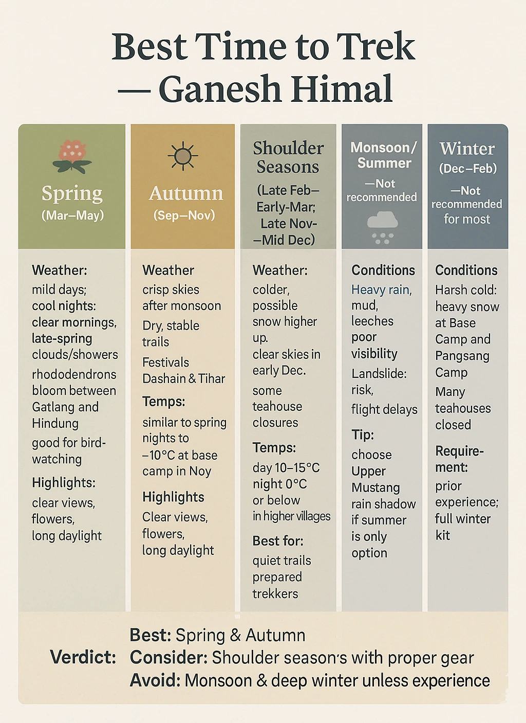
The best times to trek the Ganesh Himal are March to May and late September to November. The sky is clear, the views are scenic, and the temperature is comfortable. You can also trek during the shoulder seasons with proper preparation. We don’t recommend monsoon and winter. If you are hiking in the monsoon and winter, have prior experience, and pack the correct gear, you will be fine.
Spring (March to May): Spring has mild days and cool nights. You will see many blooming rhododendrons in lower-altitude forests between Gatlang and Hindung. Daytime temperature ranges from 15-25°C at lower altitudes and 5-10°C at the base camp. Nights can be -5 °C or even colder in the base camp. Most mornings are clear with good visibility, but afternoons can bring clouds or showers during late spring. It is also an excellent time for bird watching.
Autumn (September to November): The autumn sky is crisp and clear after the monsoon rain. It is one of the best times with panoramic views and ideal trail conditions. The temperature is similar to spring, with nights sometimes reaching -10°C at the base camp during November. Nepal celebrates Dashain and Tihar during autumn, a great time to witness the village celebrations. Trails are dry and stable with big crowds.
Shoulder Seasons: The weather is cold from late February to early March, but trekking is possible with the correct gear. There might be some snow in higher-altitude trails, but regardless, it is doable. Late November to mid-December has clear skies but icy days. Trails are less busy, but many teahouses close at higher altitudes. Shoulder seasons are ideal for trekkers who want quiet trails and can handle colder weather and occasional snow.
Monsoon/Summer (June to August): Trails are muddy with many leeches and hidden mountain views. Landslides are a high risk during the monsoon season due to loose soil. We don’t recommend monsoons for the trekking season. You can instead opt for the Upper Mustang trek, as it lies in the rain shadow.
Winter (December to February): While possible, trekking during winter is harsh. Base Camp and Pangsang Camp may have heavy snow, and temperatures can fall below -15°C.Many teahouses close due to low traffic and snow. We don’t recommend winter unless you have the correct gear and have prior trekking experience.
Ganesh Himal Trek is in a remote area with unpredictable mountain conditions. It requires flexibility for successful completion.
Weather, trail conditions, or local events may lead to a schedule change. Your guide might reroute or decide to stay an extra night in a particular village in case of snowfall, landslide, or a village festival. Even though we have buffer time in the itinerary, minor changes are common. Your guide can change the group’s safety plan or accommodate the group’s needs. The guide will delay or reroute if any group member has AMS symptoms or unsafe trail conditions. Trust your guide’s judgement and experience.
Private groups have more flexibility. You can make changes to the schedule according to your needs. You can request extra rest days, side hikes, or detouring to other villages and staying there. Depending on the logistics, we arrange last-minute arrangements.
We can add eta acclimatization or rest days before the trek so you can recover or explore. You can also return to the city a day early. The trail has limited mobile connectivity, but your guides contact our office when possible to coordinate support when necessary. Strikes, road closures, or natural events may impact transportation or logistics. Have a positive mindset to ensure safety and enjoyment. Sometimes changes may lead to lasting memories.
We offer some optional additions to the trek if you want to learn more about Nepal or travel to more places. These add-ons are entirely optional and come with extra charges.
Kathmandu Valley Sightseeing: You will tour with a guide along the Kathmandu Valley’s UNESCO World Heritage Sites. Visit Swayambhunath Stupa (Monkey Temple), Pashupatinath Temple, Bouddhanath Stupa, and the historic Durbar Squares of Kathmandu, Bhaktapur, or Patan. You get to learn Nepal’s architecture, spirituality, and centuries-old traditions.
Everest Mountain Flight: Go on an hour-long flight from Kathmandu over the majestic Himalayas of Nepal. You will see the aerial view of Everest, Lhotse, Makalu, and other towering peaks. It is ideal for those who want to see the Himalayan peaks without trekking.
Everest Base Camp Helicopter Tour: Take a half-day helicopter trip to Everest Base Camp. Your helicopter will land on Kala Patthar (5,545m) and offer great views of Mount Everest and Khumbu Icefall.
Chitwan Jungle Safari: Chitwan lies in the south of Nepal. You can enjoy jungle walks, jeep safaris, canoe rides, and cultural performances in Chitwan: spot rhinos, crocodiles, deer, and exotic birds in Chitwan National Park.
Pokhara Extension: You can relax in the beautiful lakeside city of Pokhara before or after the trek. Pokhara has a laid-back vibe, great mountain views, and adventurous activities like paragliding and zip-lining. This city is a refreshing contrast to the trekking regions.
Booking Process: You can book with us through our secure online system. Go to our website and visit the Ganesh Himal page. You can click the trek you are interested in and book the trek. Fill in your preferred trekking days, group size, and services like gear rental or single room supplement. We offer fixed group departures and private tours. To secure the booking, you can pay a 20% non-refundable deposit or the full amount upfront. If you pay the deposit, you can pay the remaining balance upon arrival or 30 days before the trek.
After the booking confirmation, fill in our details, such as name, nationality, and contact info, so that we can arrange your trekking permits. We will send a confirmation email in about a day or two. We assist with pre-departure planning, packing lists, and any extra arrangements.
What the package includes: Our package included permits, guide and porter services, meals/ accommodations in the trek, and ground transportation as per the itinerary. You are responsible for your international flight, Nepal visa, insurance, meal/accommodation in Kathmandu, tips, and personal gear. Let us know if you want a private room throughout the trek and other arrangements.
Paying Method: The deposit you pay is generally refundable, as we use it to handle logistics. You can pay the remaining balance 30 days before the trek or upon arrival in cash in NPR or major currencies like USD, EUR, GBP, etc. We accept bank transfers, cash, and major credit cards.
Cancellation Policy: We aim to keep our conditions fair. If you need to cancel the trip, email us the reason. We refund any payment minus the deposit if you cancel more than 30 days before the trek. You can use the deposit as a credit for a future trip. It is valid for a year from the original trekking date. If you cancel 15-30 days before the trek, we will refund 50% of the trek cost. After that, cancellation means no refund. You can find a replacement traveler to take your spot for a minimal fee.
We provide a full refund in cases like political unrest, natural disasters, or insufficient group size, which leads us to cancel the trek
Yes, the package includes airport transfers. We offer complimentary airport pick-up and drop-off in Kathmandu. One of our representatives will meet you at Tribhuwan International Airport and drive you to your hotel. After the trek, arrange your departure transfer. Share your flight and hotel details with us so we can make appropriate arrangements.
We provide a pre-trek briefing in Kathmandu a day before the trek. It covers itinerary, gear check, and health precautions. You will also meet your guide on the same day. We assist with any last-minute rentals or purchases. Before the trek, you’ll receive detailed information about the itinerary, packing list, and preparation tips via email.
Trekking with a Nepali company allows better cultural insight, lower costs, and direct support to the local communities. You get quicker on-ground help, personal attention, and flexible service when trekking with local companies. We know the trails better and ensure an authentic and smooth experience.
Some lower-altitude villages like Syabrubesi and Gatlang have electricity or solar. You can charge your devices there for a small fee. Don’t expect power in remote areas like the Base Camp or Pangsang Phedi. Bring a power bank and keep your devices warm in cold temperatures to preserve battery.
You might catch a signal in a village like Syabrubesi or Shertung, but most routes have no network or WiFi coverage. Our guides carry phones/radios in case of emergencies. Buy a local SIM card in Kathmandu to have a chance to have connectivity, though the service is not consistent.
You can take hot showers in the lower villages. You can get solar or gas-heated showers for a small fee in teahouses. Since no showers are in remote or higher places, we advise bringing wet wipes for a quick clean. Most trekkers use a bowl of warm water for a sponge bath. Bring a travel-size towel, soap, and wipes to stay clean.
Yes, we make arrangements for most dietary needs. Meals include dal bhat, noodles, bread, eggs, and soups. Vegan and gluten-free diets have limited choices, but we arrange them. Boiled water in teahouses comes with a fee. You can use purification tablets or a UV filter for safe drinking water.
We handle all permits for you. You need a TIMS card and a Langtang National Park or local conservation permits for the Ganesh Himal Trek. We arrange them before the trek after the booking confirmation. We will ask for a few information and passport copies for permits.
Yes, you need travel insurance. It should cover up to 4,500m, medical emergencies, and helicopter evacuations. Share your insurance details with us before the trek so we can coordinate an emergency evacuation. Travel insurance is essential for a safe trek and peace of mind.
Our group size is usually between 2 and 10 people. We also arrange solo treks or custom groups. If you are trekking solo, you get a personal guide and porter. You can also join another group if you want a group experience.
Our guides have training in first aid and carry medical kits. They provide on-trial care for mild issues. We will arrange an evacuation in case of altitude sickness or serious injuries. Our Kathmandu team will assist with hospital care and insurance communication.