

Included Meals
- Breakfast: 10
- Lunch: 11
- Dinner: 10

Unbeatable Holiday Offers – Save Up to 20% on Your Next Adventure!
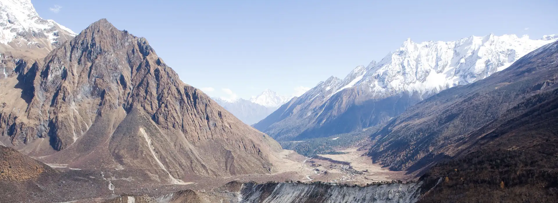
The Manaslu Circuit Trek is a challenging and rewarding route that takes you through the remote mountains of Nepal. This trek circles Mount Manaslu, the eighth-highest peak in the world, providing stunning views of its snow-covered summit throughout the trail. Along the way, trekkers can also admire other prominent peaks such as Ganesh Himal and Himalchuli. The mountains offer ever-changing panoramas, making the Manaslu Circuit Trek a visually captivating experience for all participants.
The trail passes through varied natural landscapes, from dense rhododendron and pine forests to flowing rivers and high-altitude passes. The route gradually moves from green valleys to rocky highlands near the Larkya La Pass. Trekkers will also encounter terraced fields, local streams, and occasional wildlife, making the Manaslu Circuit Trek a perfect combination of adventure and scenic beauty.
During the Manaslu Circuit Trek, you will visit traditional villages influenced by Gurung and Tibetan culture. The houses are built from wood and stone, with colorful prayer flags decorating homes and pathways. Trekkers can observe local farming and livestock practices while experiencing the warmth and hospitality of the villagers. These stops provide an authentic cultural experience and an opportunity to understand life in this remote region of Nepal.
The Manaslu Circuit Trek also includes visits to sacred monasteries such as Rachen and Mu. These monasteries are important centers of Buddhist practice, allowing trekkers to witness traditional rituals and explore ancient temples surrounded by quiet mountain scenery. The spiritual aspect of the Manaslu Circuit Trek adds depth and meaning to the experience, making it more than just a high-altitude journey.
The Manaslu Circuit Trek is suitable for those with previous trekking experience. While the trail is less crowded than many other routes in Nepal, it requires good fitness and preparation due to its high altitude and remote location. Proper acclimatization is necessary to avoid altitude sickness, especially at higher passes. With careful planning, the Manaslu Circuit Trek offers a unique combination of mountain scenery, cultural experiences, and sacred sites.
From the towering summit of Mount Manaslu to the traditional villages and monasteries along the trail, every stage of the Manaslu Circuit Trek provides an opportunity to enjoy the natural beauty, culture, and tranquility of Nepal’s remote mountains.

Included Meals

Trip staff

Transport

Accommodation

Trip Grade
Group Size
Your trip starts with a serene drive from Kathmandu, then a hike to Soti Khola. You will pass the Nepali mid hills and follow the Budhi Gandaki Khola. You will reach Arughat after about 6 to 7 hours by road. Then you hike for about 3 to 4 hours to Soti Khola village. It is also your stop for the day. Stay overnight in a simple riverside teahouse.
Start and end altitude: 1,400 m to 900 m
Elevation gain/loss: –500 m
Distance and hours: ~150 km; 6–7 hours drive
Accommodation:
Local Teahouse
Meals Lunch, Dinner

Maximum Altitude 900m/2,953ft (Machha Khola)
Difficulty
The trail starts with a little challenge of steep stone staircases and climbs out of the Machha gorge. The trail goes through rhododendron, pine, and bamboo forests, passes small Gurung settlements like Khorlabesi, and crosses several suspension bridges.
You will pass Tatopani, a popular resting point with a natural hot spring. Be careful on the landslide-prone sections. You will arrive in Jagat (1400m) by late afternoon. Jagat is a beautiful village right above a river. It is also the official checkpoint for the Manaslu Conservation Area.
Start and end altitude: 900 m to 1,400 m
Elevation gain: +500 m
Distance and hours: ~15 km; ~7 hours trek
Accommodation: Teahouse in Jagat
Accommodation:
Local Teahouse
Meals Breakfast, Lunch, Dinner
Maximum Altitude 1,400m/4,593ft (Jagat)
Difficulty
You will follow the Budhi Gandaki Khola and trek through subtropical forest, terraced hillsides, and small villages. You will cross a suspension bridge over Budi Gandaki Khola and climb towards Salleri and Sirdibas. You will notice a more substantial Tibetan cultural influence as you go further.
You will see some waterfalls and pass Mi gaon, where you’ll visit sacred caves and mani stone walls. The air gets crispier, and the terrain denser with forests. After a final push through thick pine and oak forest, you will rewatch Deng. As you enter the upper Manaslu region, Deng feels more isolated and remote than the previous villages.
Start and end altitude: 1,400 m to 1,860 m
Elevation gain: +460 m
Distance and hours: ~13 km; 6–7 hours trek
Accommodation: Teahouse in Deng
Accommodation:
Local Teahouse
Meals Breakfast, Lunch, Dinner
Maximum Altitude 1,860m/6,102ft (Deng)
Difficulty
Today, the trail climbs gradually through lush, moss-covered forests. You will pass rhododendron forests and some Budhi Gandaki gorges. You will pass hamlets like Bihi Phedi with colorful prayer flags and traditional Tibetan-style stone houses. Throughout the trail, you will see mani walls, chortens, and alpine farmlands and notice more Tibetan Buddhist culture.
You will reach Namrung (2,360m) by afternoon. Namrung is a Gurung village with many stone houses and teahouses. You will get your first clear views of Ganesh Himal, Himalchuli, and Mount Manaslu. It is also a cultural gateway to the Nubri Valley. You will rest in Namrung overnight.
Start and end altitude: 1,860 m to 2,630 m
Elevation gain: +770 m
Distance and hours: ~10 km; 5–6 hours trek
Accommodation: Teahouse in Namrung
Meals Breakfast, Lunch, Dinner
Difficulty
After breakfast, you continue trekking through dense pine forests and leave the lower farmland and villages behind. The trail climbs steadily for about 550 m, and the elevation is 3,180m by afternoon.
Lho is a small Tibetan-style village known for its peaceful atmosphere and rich traditional cultural heritage. The town has an ancient monastery and a nunnery, both essential parts of the Buddhist culture. You can spot colorful wildflowers during spring with the beautiful skyline views of the Manaslu range.
Start and end altitude: 2,630 m to 3,180 m
Elevation gain: +550 m
Distance and hours: ~12 km; 6–7 hours trek
Accommodation: Teahouse in Lho
Meals Breakfast, Lunch, Dinner
Difficulty
Today’s trek begins with a steady ascent through fir forest, then passes alpine streams and small shrines. As you continue trekking, you will reach Shyala (3.390m) where the dense forests start thinning. The view is even better with the open alpine meadow and colorful wildflowers, especially during spring. The ascent continues and reaches Sama Gaon at 3,520m, gaining around 340m in altitude.
Sama gaon is a large village with traditional stone lodges, a prayer wall, and a local marker. It is an important cultural hub and a gateway to the higher Manaslu region. The villages offer panoramic views of Mount Manaslu, Himalchuli, and other mountains against the skyline.
Start and end altitude: 3,180 m to 3,520 m
Elevation gain: +340 m
Distance and hours: ~8 km; ~5 hours trek
Accommodation: Teahouse in Sama Gaon
Meals Breakfast, Lunch, Dinner
Difficulty
Today is an acclimatization day at Sama Gaon. You will hike to a nearby place, then return to rest. It helps with acclimatization and increases red blood cells in the body.
The hike to Rachen Monastery at 3,800m is among the most popular acclimatizing hikes. The round trip is about 6 to 6 hours and includes a 300m elevation gain. You will pass yak pastures, small villages, and important cultural sites.
You also have the option to explore nearby viewpoints or smaller monasteries. After the hike, you can relax in the teahouse for the rest of the day.
Start and end altitude: 3,520 m
Elevation gain: Optional +300 m (day hike)
Distance and hours: 0 km trekking; optional 6–7 hours day hike
Accommodation: Teahouse in Sama Gaon
Meals Breakfast, Lunch, Dinner
Difficulty
You will begin the trek with a gentle ascent through open alpine meadows and grassy slopes towards the Tibetan plateau. You will pass a few settlements like Dharmasala, where you’ll experience a peaceful rural lifestyle in the highlands of Nepal. By early afternoon, you will gradually climb into Smado at 3,875m, a tiny yak-herding village. You will gain about 360 m in elevation and reach the ancient Nepal-Tibet trade route.
You will enjoy the incredible views of Ganesh Himal and the surrounding peaks from Samdo. This village is the highest point of the Manaslu Region and is the starting base for the upcoming challenging days.
Start and end altitude: 3,520 m to 3,875 m
Elevation gain: +355 m
Distance and hours: ~12 km; 4–5 hours trek
Accommodation: Teahouse in Samdo
Meals Breakfast, Lunch, Dinner
Difficulty
Today you will ascend from Samdo to Dharmasala or Larkya Bhich at 4,3360m. The trail takes you through a rocky field, crossing a rocky moraine and glacial streams. You will notice a change in the landscape from dense forests to a harsh and alpine environment. You will reach the Larkya Bazaar, a trading hub, then continue to Dharmasala, a remote village with few lodges. It is also a crucial stop before the Larkya La Pass.
Start and end altitude: 3,875 m to 4,360 m
Elevation gain: +485 m
Distance and hours: ~8 km; 5–6 hours trek
Accommodation: Basic stone shelter (Dharmasala)
Difficulty
Today is the most demanding day of our trek. You trek for about 9 to 10 hours, covering about 17 km. You will climb to the trek’s highest point, Larkya La Pass at 5,106m, and gain about 750m elevation. Then, you will descend around 1,400m down to Bhimthang at 3,700m.
Your trek begins pre-dawn with a climb through loose scree slopes, prayer flags, and thin air. You will reach the pass around sunrise and see the beautiful golden view of Manaslu and the Annapurna ranges.
After resting briefly, you will begin your long descent down to Bhimthang. As you enter the valley, you pass yak pastures, lush valleys, glacial streams, and rhododendron forest. Bhimthanf is a peaceful village with many teahouses and lodges.
Start and end altitude: 4,360 m to 3,700 m (via 5,106 m)
Elevation gain/loss: +750 m ascent, –1,400 m descent
Distance and hours: ~17 km; 9–10 hours trek
Accommodation: Teahouse in Bimthang
Meals Breakfast, Lunch, Dinner
Difficulty
The trek begins with a steady descent to Dharapani, dropping about 1,800m. You will pass diverse landscapes with dense pine and oak forests. You will cross many suspension bridges and enjoy the beautiful mountain views throughout the trail.
The trail takes you through many small villages and crosses the principal waterway of the region, the Marshyangdi River. You will reach Dhrapani after hiking for about 7 to 8 hours. It is a lively village marking the end of the Manaslu Circuit trek.
Start and end altitude: 3,700 m to 1,900 m
Elevation loss: –1,800 m
Distance and hours: ~20 km; 7–8 hours trek
Accommodation: Teahouse in Dharapani
Meals Breakfast, Lunch, Dinner
Difficulty
Today is your final day in the mountains. You will leave the village and enjoy the scenic drive back to Kathmandu. The road follows the beautiful Marsyangdi and Trishuli river valleys. You will reach Kathmandu after about 7 to 9 hours of driving, covering about 200km.
Before arriving in Kathmandu, you will enjoy glimpses of terraced hillsides, local villages, and river landscapes. You will check into your hotel and officially mark the end of the trek.
Start and end altitude: 1,900 m to 1,400 m
Elevation loss: –500 m
Distance and hours: ~200 km; 7–9 hours by vehicle
Accommodation: Not Included
Meals Breakfast, Lunch
Difficulty
Accommodation on the trail is at local, family-run teahouses. These lodges are modest and cozy. You get a room with two or three simple beds, foam mattresses, and thin blankets. We recommend a sleeping bag for warmth against the cold nights. You get shared bathrooms with a squat-style toilet. Hot showers are available with an extra charge. Since electricity is limited. Charging devices will also cost you a fee. WIFI and connectivity are slow and often unavailable in higher elevations.
Accommodation is certainly different in the cities and the trail. The modest teahouses are a part of the trekking experience, so approach them with a clear mind.
We rate the Manaslu Circuit trek as moderate in terms of difficulty. You will walk for 12 consecutive days on rugged, remote, and steep trails. You will be hiking 5 to 7 hours daily and even longer when going through high passes. The maximum trek altitude is 5,106m at Larkya La Pass. This high altitude has thin air with cold conditions.
This trek has no technical climbs; however, you must have good physical health. You should be fit enough to walk on uneven terrain and carry a daypack for several hours daily.
The trail has many challenging sections, including stone steps and long descents. However, with proper acclimatization and preparation. The trek is achievable for many. We do recommend prior hiking experience to manage this one.
The Manaslu Circuit trek is among the most iconic adventures in Nepal. Prepare your mental and physical health to enjoy it fully.
You need proper physical fitness for the Manaslu Circuit Trek. Begin training your body about 8 to 12 weeks before the trek. Brisk walking, jogging, cycling, or swimming are good ways to build stamina. Wear your full gear to practice hikes with elevation gain on the weekends.
Descending is especially hard on the knees. Build your core and leg endurance by practicing lunges, squats, and planks. Go on long hikes with a loaded backpack to get used to some trekking conditions. Start the training with 45 minutes and gradually increase to 2-3 hours. Gradual training makes the body fit and trekking easier. Stretching and yoga are also exercises to improve flexibility and balance. Don’t strain or overexert your body. Stop training a week before the trek so you don’t injure your body.
Trekking over 2,500m exposes you to the risks of altitude sickness. There is no definitive cure for severe altitude sickness except immediate descent. Headaches, nausea, dizziness, and insomnia are common early signs of altitude sickness. Walk at a steady pace without any hurry and take multiple breaks to prevent altitude sickness. High altitude also drains moisture from the body, so hydrate well. You should eat and drink well, even if you don’t like it.
Eat high-carb food and hot liquids. Snack on energy bars mid-trip for an instant energy boost. We follow the principle of climbing high and sleeping low. This strategy stimulates the body, produces red blood cells, and provides oxygen.
Your guides are knowledgeable about altitude sickness. Inform them immediately if you feel any discomfort. They may pace you down, stop the trek for the day, or give you medication. You should also take medicine like acetazolamide if your doctor advises it.
Hydration and pacing yourself are the keys to a safe trek. Listen to your body and inform the guide in case of any illness. Safe travel!
Indian nationals don’t need a tourist visa to go to Nepal. Some SAARC countries get a visa-free visit for a short term and a discount on the visa fee. You can get a visa on arrival at the Tribhuvan International Airport in Kathmandu.
Since the Manaslu Circuit Trek is a 13-day trek, you can purchase a 15-day visa for USD 30. Ensure you have at least 6 months of passport validity and a few blank pages for approval.
You can also get a Nepal tourist visa from your local Nepal Embassy. Check the Nepal Department of Immigration website for details on the visa fee and extensions.
Nepal uses the local currency, Nepali Rupees or NPR. One USD is around NPR 140. The rate fluctuates constantly, so check the date during your trekking period for precise information.
The trail doesn’t accept cards or foreign currency, so you must carry Nepali rupees for any purchase. There are many ATMs in Kathmandu and Pokhara, but none on the trail. You can also exchange money in money-exchanging centres in Kathmandu and Pokhara. The package includes all major expenses like accommodation and meals, but you must pay for yourself to buy anything. The lodges charge extra for hot showers, charging electronics, and WIFI. You can spend around $20-$30 per day. You also need to tip your trekking team at the end of the trek. Plan your budget and carry your cash accordingly.
Learning and respecting the culture and beliefs of the people you visit is essential. Since you are stepping into the land of people with many cultural and traditional values, you must respect them.
Nepal follows a mix of Hindu and Buddhist practices. Dress modestly and cover your shoulders/knees when staying in villages. Take your hat and shoes off while entering any religious sites. Walk clockwise in monasteries and maintain a friendly smile.
Don’t click pictures of people without consent. Ask permission and respect their choice. You can learn basic Nepali phrases like “Namaste” and “Dhanyabad”. Make a prayer hand pose and bow slightly while saying Namaste to greet people, and saying Dhanyabad to express your gratitude.
People don’t appreciate public displays of affection, so refrain from doing so. The locals will feel uncomfortable and will frown upon your actions. Tip your local staff as a gesture of thanks.
Nepal is generally a safe country, but petty theft can happen. Besides this, the trail can be risky as well. Follow your guide’s plan and trek on the marked trails to prevent trail-related risks. Some sections can be slippery due to rain or snow, and the weather can quickly change. It is best to stay prepared for any weather. Avoid drinking tap or unfiltered water. Take a water purification tablet or a filter to drink safe water and prevent waterborne bugs.
Carry a headlamp with extra batteries for pre-dawn hikes and nighttime bathroom trips. Bring a personal first aid kit and enough personal medications. Inform your guide immediately if you feel any discomfort. Give an itinerary, travel insurance information, passport copies, and emergency contact number to your trusted family or friend for safety.
We mandate travel insurance for all trekkers. The trail is generally safe, and emergencies occur rarely, but it’s always better to stay prepared.
Your insurance should cover high-altitude trekking up to 5,000m, emergency helicopter rescue, and medical expenses. You can contact us if you are unsure of which insurance to purchase. It’s better if your insurance also covers trip cancellation. You need to provide your insurance details to us so we can operate an emergency evacuation without any hassles. Carry a printed/digital copy of your insurance details and emergency contact numbers. Helicopter evacuations can be financially draining without insurance. We require travel insurance for your safety.
Our guides and porters will accompany you on the trek. They are an essential part of making the trek successful.
We provide licensed, English-speaking guides for your Manaslu Circuit Trek. They have mountain training in first aid and will conduct the first medical procedure in case of any injuries/sickness. They have the local knowledge and will act as a bridge between you and the local people of the trek. They will lead the group, check on everyone, choose the best route, and share their knowledge on the region’s culture, nature, and history.
Porters carry your main duffel bag so you can trek with just your daypack. They carry up to 15kg per person and are strong individuals with local knowledge. We ensure fair and ethical working practices so our porters don’t face mistreatment. We don’t allow overloading our porters, pay them fair wages, and provide proper gear, nutritious meals, and sufficient rest. We advise trekkers not to overpack so the trek is enjoyable for everyone.
While we try our best to follow the planned Itinerary, we recognise that mountains are unpredictable. Weather/trail conditions, road access, or group fitness can influence the Itinerary. We adjust the Itinerary and ensure flexibility when needed. We can arrange overnight stops, skip optional side trips, or add extra acclimatization if necessary. Your guide may reroute or delay the trek for safety in heavy rain, snowfall, or landslides. Private groups have even more flexibility. We can customize departure dates and add other arrangements.
Remote trekking comes with unexpected changes, so it’s best to trek with an open mind. We will manage all adjustments professionally so you can trek safely.
Spring (March-May): Spring offers clear skies with warm daytime temperatures. Night temperature can still be freezing in higher altitudes. The trails have blooming rhododendrons and wildflowers in lush forests. Spring is popular among many trekkers. ‘
Autumn (September-November): The weather is dry and stable. Clear skies offer great mountain views. Locals celebrate the main Nepali festivals of Dashain nd Tihar, making the atmosphere cultural and lively. Days are mild and nights are cold. It is the most popular trekking season, and thus, it is crowded.
Monsoon (June-August): Monsoon or summer brings heavy rainfall and landslides to lower altitudes. Villages above 3,000m are dry but still risky. Trekking this season is extremely risky, so we don’t recommend it. The wet conditions flood the trial with many leeches.
Winter (December-February): Winter has freezing temperatures. Snow is common anywhere above 3,000m. Lower altitudes have 5-10°C days and below-freezing night temperatures. Larkya La Pass and the Samdo area get lots of snow. We don’t recommend this season unless you are an experienced trekker with the right gear.
Shoulder Seasons (Late February, early June, or September): Shoulder seasons still have stable weather with fewer trekkers. February does have cold nights, and June may get early rain, but other conditions are ideal.
If you have time left on your visa or want to explore the country more, we offer various add-ons. These add-ons are entirely optional and will cost extra. We fully understand and respect your choice regardless.
Cultural Activities: You can attend an ethnic cultural dance or a Nepali music evening according to your preference. We can arrange a dinner with a cultural dance performance after the trek. You can volunteer at local schools or community projects as well. We also arrange private homestays if you want a more intimate Nepali experience.