The Annapurna Circuit Trek Guide helps travelers plan one of Nepal’s most varied trekking routes. The trail circles the Annapurna range, climbs through Manang Valley, crosses Thorong La Pass at 5,416 meters, and descends toward Muktinath, Kagbeni, Jomsom, and the Kali Gandaki Valley. Road access has changed parts of the route. A smart itinerary still delivers strong mountain scenery, cultural depth, and a rewarding high-pass trek.
Most modern itineraries take 12 to 18 days, depending on the starting point, side trips, and transport choices. This guide covers the full route, road impact, a 15-day itinerary, Thorong La Pass, altitude profile, permits, guide rules, cost, best time, side trips, accommodation, packing, altitude safety, and common mistakes to avoid.
Quick Answer: Annapurna Circuit Trek Guide
The Annapurna Circuit Trek circles the Annapurna massif in Nepal. Most modern itineraries take 12 to 18 days. The route crosses Thorong La Pass at 5,416 meters and requires ACAP, current TIMS documentation, and guide support under official NTB guidance.
What Makes the Annapurna Circuit Special?
Major Landscape Variety
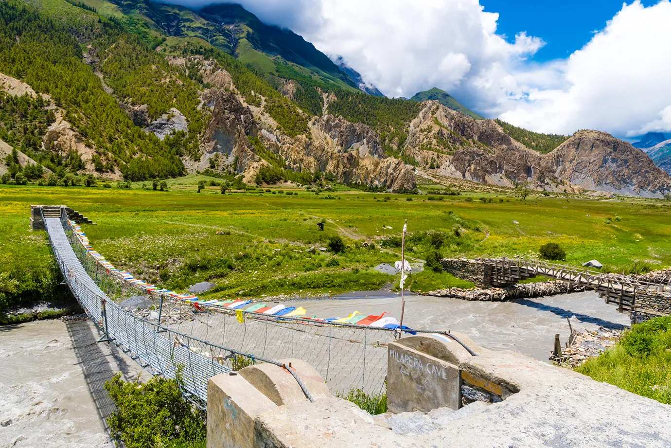
The route moves through subtropical lower valleys, pine and rhododendron forests, high ridges around Pisang and Ngawal, dry Manang terrain, alpine yak pastures, and the Kali Gandaki rain-shadow valley. No other standard Nepal trek covers this range of geography in one trip.
Strong Cultural Diversity
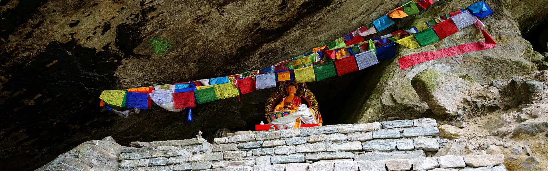
Gurung villages, Manangi Buddhist culture, Braga monastery, Muktinath pilgrimage site, Thakali villages, Marpha apple orchards, and Kagbeni’s Mustang gateway atmosphere line the route. The cultural variety runs deeper and wider than most single-region treks in Nepal.
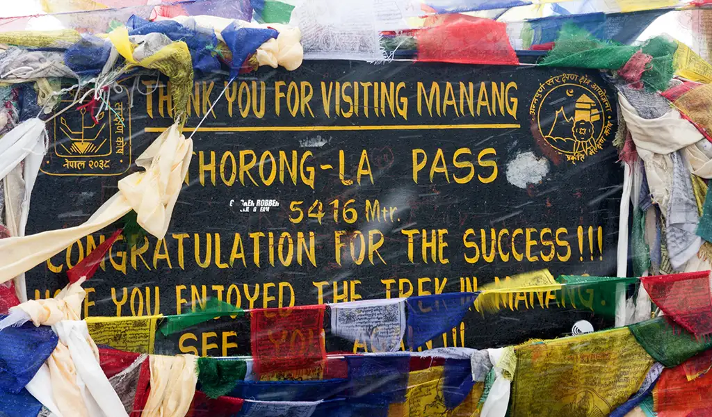
Thorong La Pass
Thorong La Pass at 5,416 meters gives the trek a clear high-altitude goal. The pass crossing rewards trekkers with a physical achievement, wide mountain views, and the dramatic descent to Muktinath on the other side.
Road Impact and Trail Reality
Road construction changed the classic Annapurna Circuit. Besisahar to Chame includes road access. Muktinath to Jomsom and farther south also includes road access. Many trekkers now skip dusty road sections by jeep. The core trekking section from Chame through Upper Pisang, Manang, Thorong La, Muktinath, Kagbeni, and Marpha still holds strong value. NATT-style trails follow road-free footpaths, helping reduce road walking. Upper Pisang, Ghyaru, and Ngawal offer the best road-free alternatives.
| Section | Trail Feel | Planning Advice |
|---|---|---|
| Besisahar to Dharapani | More road impact | Drive if short on time |
| Dharapani to Chame | Mixed road and trail | Walk selected trails or NATT options |
| Chame to Upper Pisang | Strong trekking value | Walk and use the upper trails |
| Upper Pisang to Manang | Excellent scenery | Walk via Ghyaru and Ngawal |
| Manang to Thorong La | Classic trekking section | Walk slowly and acclimatize |
| Thorong La to Muktinath | Major trekking highlight | Start early, protect knees |
| Muktinath to Jomsom | Road impact but scenic | Walk, jeep, or mix both |
| Jomsom to Tatopani | More road impact | Drive unless doing a classic extension |
| Tatopani to Ghorepani | Strong trail section | Add for Poon Hill and forests |
Thorong La Pass: The Main Challenge
| Detail | Information |
|---|---|
| Altitude | 5,416 m |
| Connects | Manang side with Muktinath / Kali Gandaki side |
| Usual start | Thorong Phedi or High Camp |
| Finish | Muktinath |
| Walking time | 7-10 hours |
| Technical level | Non-technical in normal conditions |
| Main risks | Altitude, cold, wind, snow, long descent |
| Best season | Autumn and spring |
Most trekkers start around 4:00 to 5:00 AM. The ascent feels slow due to altitude. The descent to Muktinath stresses the knees. Fresh snow, wind, or poor visibility delays many crossings. Trekking poles help on both sides. Microspikes help after snowfall but remain optional in dry conditions.
Quick Answer: How difficult is Thorong La Pass?
Thorong La Pass ranks as the hardest day on the Annapurna Circuit. It reaches 5,416 meters and requires an early start, steady pacing, warm layers, good fitness, and proper acclimatization before the crossing.
Direction: Counterclockwise Works Best
Nearly all trekkers follow the counterclockwise route: Besisahar/Chame to Manang, then Thorong La to Muktinath. The counterclockwise direction builds altitude gradually. It gives trekkers more time to acclimatize before the pass. The clockwise route climbs too quickly from the Muktinath side for most travelers. Only very experienced trekkers with strong altitude knowledge should consider the clockwise direction.
Annapurna Circuit Trek Itinerary: 15 Days
| Day | Route | Altitude | Walk Time | Notes |
|---|---|---|---|---|
| 1 | Arrive Kathmandu | 1,400 m | — | Hotel, briefing |
| 2 | Drive to Dharapani/Chame | 1,860-2,670 m | — | Long road transfer via Besisahar |
| 3 | Trek to Upper Pisang | 3,300 m | 5-6 hrs | Better views than the lower route |
| 4 | Trek to Manang via Ghyaru/Ngawal | 3,540 m | 6-7 hrs | High trail, culture, mountain views |
| 5 | Acclimatization in Manang | 3,540 m | 2-5 hrs | HRA talk, Gangapurna Lake, Braga |
| 6 | Optional: Ice Lake hike | ~4,620 m | 5-7 hrs | For fit trekkers only |
| 7 | Trek to Yak Kharka | 4,018 m | 3-4 hrs | Gradual altitude gain |
| 8 | Trek to Thorong Phedi | 4,525 m | 3-4 hrs | Pre-pass stop |
| 9 | Cross Thorong La to Muktinath | 5,416 m pass | 7-10 hrs | Main challenge of the day |
| 10 | Trek/drive to Kagbeni | 2,810 m | 3-4 hrs | Mustang gateway village |
| 11 | Trek/drive to Marpha or Jomsom | 2,670 m | 2-5 hrs | Thakali culture, Apple village |
| 12 | Drive or fly to Pokhara | 820 m | Variable | Road or Jomsom flight |
| 13 | Rest in Pokhara | 820 m | — | Buffer after road/flight delays |
| 14 | Drive or fly to Kathmandu | 1,400 m | — | Return to the capital |
| 15 | Departure | — | — | Trip ends |
Important: Do not skip the Manang acclimatization day. Manang remains the most important safety stop before Thorong La.
Altitude Profile
| Place | Approx. Altitude |
|---|---|
| Besisahar | 760-820 m |
| Dharapani | 1,860 m |
| Chame | 2,670 m |
| Upper Pisang | 3,300 m |
| Manang | 3,540 m |
| Ice Lake / Kicho Tal | ~4,620 m |
| Yak Kharka | ~4,018 m |
| Thorong Phedi | ~4,525 m |
| High Camp | ~4,850 m |
| Thorong La Pass | 5,416 m |
| Muktinath | ~3,760 m |
| Kagbeni | ~2,810 m |
| Jomsom | ~2,720 m |
| Marpha | ~2,670 m |
Key Villages and Cultural Highlights
- Chame: District headquarters of Manang. Good lodges. Views of Lamjung Himal and Annapurna II.
- Upper Pisang: Traditional village above the lower road. Strong Annapurna II views. Better cultural feel than Lower Pisang.
- Ghyaru and Ngawal: High trail villages. Excellent views. Best road-free alternative before Manang.
- Manang: Main acclimatization hub. HRA altitude talks. Gangapurna Lake. Braga monastery is nearby.
- Muktinath: Sacred pilgrimage site for Hindus and Buddhists. First major stop after Thorong La.
- Kagbeni: Medieval-style village near the Upper Mustang gateway. Strong Tibetan-influenced character.
- Marpha: Thakali village. Apple orchards. Clean stone lanes. Good cultural stop after Jomsom.
Side Trips Worth Adding
| Side Trip | Extra Time | Max Altitude | Best For |
| Ice Lake / Kicho Tal | Half to full day | ~4,620 m | Acclimatization hike and mountain views from Manang |
| Tilicho Lake | 2-4 days | ~4,919 m | Fit trekkers seeking dramatic lake scenery |
| Poon Hill extension | 3-4 days | 3,210 m | Sunrise views and classic forest finish |
| Nar Phu Valley | 5-7+ days | High pass | Experienced trekkers; restricted permit needed |
Best Time for the Annapurna Circuit Trek
| Season | Months | Thorong La Conditions | Views | Rating |
|---|---|---|---|---|
| Autumn | Sep-Nov | Usually most stable | Excellent | Best |
| Spring | Mar-May | Good, snow possible | Good to excellent | Strong |
| Winter | Dec-Feb | Snow/ice risk | Clear on good days | Experts only |
| Monsoon | Jun-Aug | Risky, wet lower areas | Mixed | Not ideal |
Difficulty and Fitness
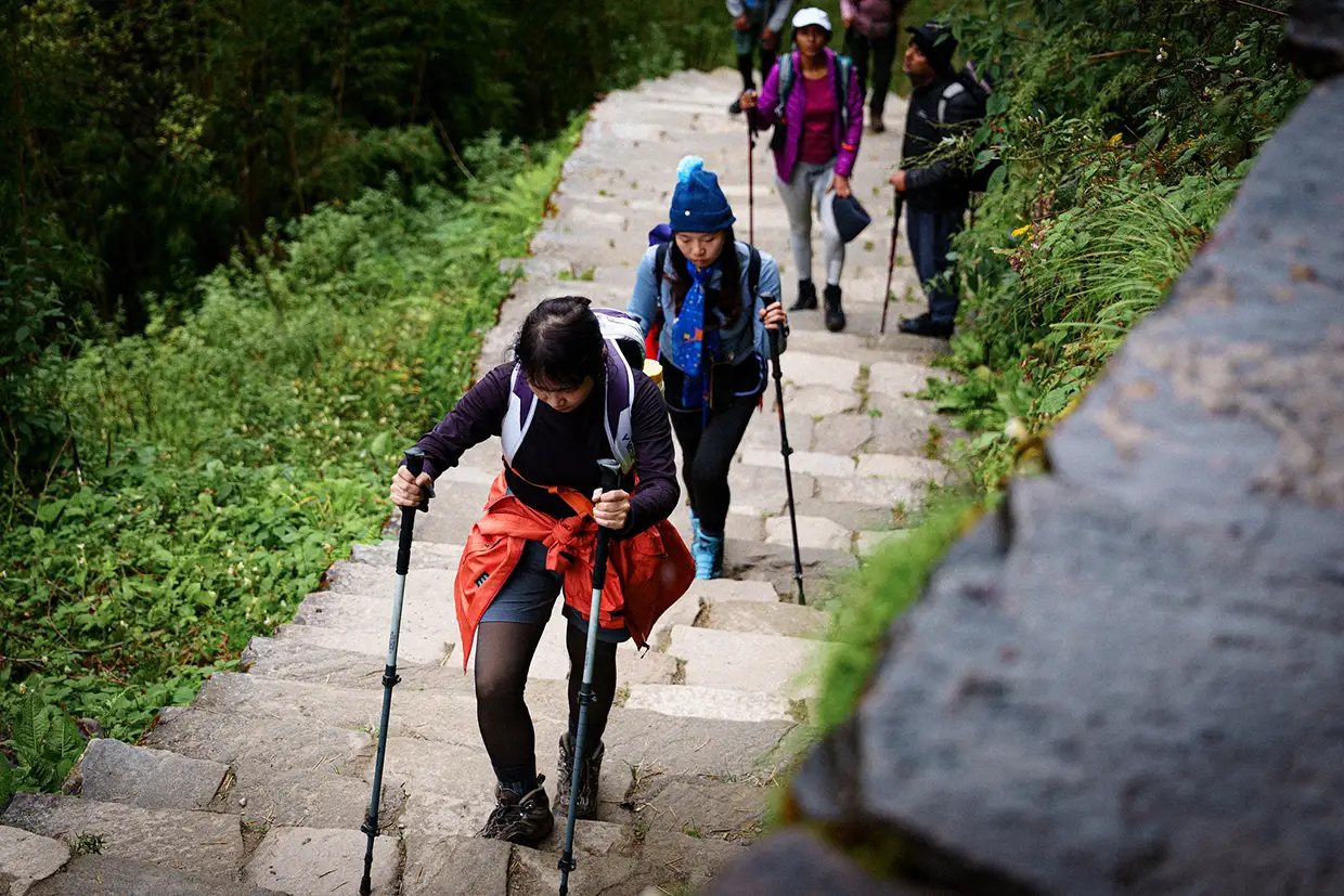
The Annapurna Circuit rates moderate to challenging. Thorong La Pass at 5,416 meters, the long pass day, sustained altitude above Manang, cold mornings around Thorong Phedi, and the steep descent to Muktinath test fitness and mental strength. Trekkers should walk five to seven hours a day, complete one seven-to-ten-hour pass day, climb stairs or hills without heavy strain, and handle cold early starts. Train for 8 to 12 weeks before departure with hill walks, stairs, squats, step-ups, lunges, and back-to-back walking days.
Annapurna Circuit vs Other Nepal Treks
| Factor | Annapurna Circuit | Everest Base Camp | Manaslu Circuit | Annapurna BC |
|---|---|---|---|---|
| Duration | 12-18 days | 12-14 days | 14-18 days | 7-12 days |
| Highest point | Thorong La, 5,416 m | Kala Patthar, ~5,545 m | Larke La, 5,106 m | ABC, 4,130 m |
| Route style | Circuit | Out-and-back | Circuit | In-and-out |
| Cultural variety | Very high | Sherpa-focused | Strong remote | Gurung-focused |
| Road impact | Significant lower | Minimal | Growing lower | Low-moderate |
| Restricted permit | No | No | Yes | No |
Permits and Guide Rules
| Permit / Rule | Required? | Notes |
|---|---|---|
| ACAP (Annapurna Conservation Area Permit) | Yes | NPR 3,000 for foreigners, NPR 1,000 for SAARC |
| TIMS card | Yes | Agency-issued under the NTB revised provision |
| Licensed trekking guide | Yes | Under the NTB revised provision |
| Restricted Area Permit | No | Standard route; needed only for Nar Phu or Upper Mustang |
Cost Overview
Cost changes with route length, transport choices, hotels, guide quality, porter use, side trips, and service level. The Annapurna Circuit usually costs less than the Everest Base Camp Trek because road access replaces mountain flights.
| Trek Style | Best For | Main Cost Factors |
|---|---|---|
| Budget guided | Cost-conscious trekkers | Basic lodges, local transport, guide, permits |
| Standard guided | Most travelers | Guide, porter, meals, lodges, transport, permits |
| Comfort trek | Private groups | Better lodges, private guide, extra support |
| Extended classic | Classic route lovers | More days, Poon Hill, Tatopani, extra meals |
Accommodation and Food
Teahouses operate along the standard route. Lower sections and villages such as Manang, Jomsom, Kagbeni, and Marpha offer greater comfort. Thorong Phedi and High Camp stay basic. Bedrooms remain unheated. Dining rooms provide the main warmth. Hot showers and charging cost extra. Common meals include dal bhat, noodle soup, fried rice, pasta, potatoes, eggs, porridge, tea, and hot lemon. Marpha serves apple pie and apple brandy. Thakali food in the Kali Gandaki region adds variety. Food prices rise at higher altitudes.
Packing List
Clothing and Layers
- Base layers, fleece, down jacket, waterproof jacket, windproof shell
- Trekking pants, warm hat, sun hat, gloves, buff
Footwear
- Broken-in trekking boots, warm socks, liner socks, camp shoes
- Gaiters if snow risk exists near Thorong La
Gear
- Daypack, duffel bag, sleeping bag, trekking poles
- Headlamp, sunglasses, water bottles, purification tablets
- Power bank, first-aid kit, personal medicines
Thorong La Pass-Day Essentials
Keep gloves, a windproof layer, water, snacks, a headlamp, and a warm hat accessible on pass day. Do not pack these deep inside the duffel. The early start at 4:00-5:00 AM demands quick access to warm layers and energy food.
Altitude Safety
- Keep the Manang acclimatization day — treat it as essential, not optional
- Attend the HRA altitude talk in Manang when available
- Walk slowly above Manang
- Do not rush from Manang to Thorong La
- Start the Thorong La crossing early in the morning
- Do not continue higher if symptoms worsen
- Carry insurance covering high-altitude trekking and helicopter evacuation
- Let the guide decide during snow, wind, or poor visibility
Shortened Route Options
| Option | Days Saved | What Changes |
|---|---|---|
| Drive to Dharapani | 1-2 days | Skips the lower road section |
| Drive to Chame | 2-3 days | Starts near stronger trekking sections |
| End at Jomsom | 2-4 days | Skips Tatopani and Poon Hill extension |
| Fly Jomsom to Pokhara | 1 day | Saves rough road travel, weather-dependent |
| Add Poon Hill | Adds 3-4 days | More forest, sunrise, and a classic finish |
Common Mistakes to Avoid
- Skipping Manang acclimatization day
- Choosing a route without understanding road sections
- Starting the Thorong La crossing too late in the morning
- Packing too lightly for a pass-day cold
- Underestimating the long descent to Muktinath
- Wearing new boots without breaking them in
- Ignoring altitude symptoms above Manang
- Skipping upper trails via Pisang, Ghyaru, and Ngawal
- Not carrying enough cash for remote teahouses
- Forgetting travel insurance
- Booking no buffer days after the trek
- Treating Tilicho Lake as an easy add-on
Frequently Asked Questions
Q: How many days does the Annapurna Circuit take?
A: Most modern itineraries span 12 to 18 days. A shorter route starts in Dharapani or Chame and ends in Jomsom, while the classic route continues through Tatopani, Ghorepani, and Poon Hill. This timeframe allows for proper acclimatization and village exploration throughout the journey. Selecting the right duration depends on your preferred pace and interest in exploring side trails, such as Tilicho Lake. It is vital for a safe mountain experience.
Q: Does the Annapurna Circuit still feel worth doing?
A: Yes, the core route from Chame through Manang, Thorong La, Muktinath, Kagbeni, and Jomsom remains highly valuable despite road construction. Upper trails and alternative routes allow successful trekkers to reduce road walking successfully. These scenic variations preserve the classic trekking experience while offering diverse cultural encounters. Most travelers find that the high altitude landscapes and local hospitality make the entire journey deeply rewarding. It remains a top global hiking destination.
Q: How difficult is Thorong La Pass?
A: Thorong La is ranked as the hardest day of the trek. It reaches 5416 meters and requires an early start, warm clothing, strong fitness, and proper acclimatization to cross safely. The ascent is steep and sustained, demanding mental resilience and physical stamina. Most trekkers find that a slow, steady pace is the most effective way to reach the summit. Preparation is key to managing the extreme physical effort.
Q: What permits do I need?
A: You must obtain the Annapurna Conservation Area Permit and a TIMS card. The standard route for this circuit does not require a restricted area permit. Carrying these documents is mandatory as you will encounter several checkpoints along the trail. Ensuring your permits are in order before departure prevents delays and supports local conservation efforts and trail maintenance throughout the protected area. Proper documentation ensures a smooth and legal journey through the mountains.
Q: Do I need a guide?
A: Yes, Nepal Tourism Board provisions require a licensed trekking guide and an agency-issued TIMS card for protected area routes. It is best to confirm current field practices before booking. A professional guide provides essential navigation support, manages altitude safety protocols, and offers deep cultural insights. Their presence significantly enhances the security and educational value of your high-altitude Himalayan trekking experience. They are your primary resource for local knowledge.
Q: Best time for the Annapurna Circuit?
A: Autumn provides the most stable pass conditions and clearest views, while spring offers warmer weather and blooming forests. Winter and monsoon seasons require significantly more caution. Choosing the right season ensures optimal visibility of the peaks and reduces the risk of weather-related delays. While autumn is the busiest period, spring offers a more colorful landscape with rhododendrons in full bloom. Each season offers a distinct mountain perspective.
Q: Can beginners do the Annapurna Circuit?
A: Fit beginners can complete the trek with training, guide support, and proper acclimatization. It is recommended to choose a steady itinerary that includes a rest day in Manang. Starting a fitness program several weeks before departure helps build the necessary endurance for long days on the trail. With professional support and a conservative pace, the circuit is achievable for active newcomers. Mental preparation is just as important.
Q: Does Tilicho Lake add value?
A: Yes, Tilicho Lake adds strong scenic value to the journey. However, it also increases the total altitude, time, and difficulty, making it best for fit trekkers with extra days. The detour takes you to one of the highest lakes in the world, surrounded by stunning glacial peaks. It requires additional physical effort but rewards you with some of the most dramatic views. It is a highlight for many strong walkers.
Q: Which direction works best?
A: Traveling counterclockwise works best as it allows for a gradual altitude buildup from the Manang side before crossing the pass to Muktinath. This direction is safer and more popular because it significantly reduces the risk of altitude-related illnesses. The ascent from the west side is much steeper, making the clockwise route far more physically demanding and potentially dangerous for those not properly acclimatized. Safety should be your priority.
Q: How does the Circuit compare with Everest Base Camp?
A: The Annapurna Circuit offers a wider variety of landscapes and a high altitude crossing at a lower cost. Everest Base Camp features the classic route with higher sleeping altitudes. Both treks require high fitness, proper acclimatization, and good pacing. While Everest is focused on the world’s highest peak, Annapurna provides a more diverse cultural experience through various ethnic villages and terrains. Both offer life-changing mountain views.
Q: Do I need a sleeping bag?
A: Yes, a warm sleeping bag is necessary because high altitude rooms can become very cold. It significantly improves comfort near Manang, Thorong Phedi, and High Camp. While teahouses provide blankets, they are often insufficient during the freezing nights at higher elevations. Having your own bag also ensures better hygiene and a more consistent level of warmth throughout the entire trek. It is an essential item for a good night’s rest.
Q: Does the standard route need a restricted area permit?
A: No, the standard Annapurna Circuit does not require a restricted area permit. These permits are mandatory only for specific side routes, such as Nar Phu or Upper Mustang. For the majority of trekkers following the main path through Thorong La, the standard ACAP and TIMS cards are sufficient. Always check for the latest government regulations before starting your trek to ensure full compliance. It saves time and stress during your travel.
Final Advice
The Annapurna Circuit Trek still ranks among Nepal’s most rewarding routes when well planned. Road access changed the lower trail. The core section through Upper Pisang, Ngawal, Manang, Thorong La Pass, Muktinath, Kagbeni, and Marpha still delivers strong scenery, cultural variety, and a real high-pass experience. Before booking, confirm the current permit and guide rules with a registered agency. Choose the right season. Use upper trails to avoid road sections. Train for Thorong La. Respect the Manang acclimatization day. Add buffer days. Prepare for cold pass mornings. The Annapurna Circuit rewards those who plan well and walk steadily.