
The Annapurna Circuit takes you from warm, subtropical valleys to icy alpine zones. Your trek begins among the rice terraces about 800m above sea level. As you trek and climb through the steady trail, you will end up at the highest point of the trek, Thorong La Pass at 5,416. You’ll reach one of the hardest passes in the world as you get to the pass. In this blog, we have provided detailed information about the Annapurna Circuit Trek Height.
You get exposed to a variety of climates and terrain in a short period with your rapid ascent through the Annapurna Circuit. You can plan acclimatization stops, adjust pace, and prepare mentally and physically if you understand the elevation profile. The trek fully introduces Nepal’s diverse landscapes in just two weeks, from green lowlands to remote Himalayan peaks.
Day-by-Day Elevation Breakdown
Day 1 – Kathmandu to Besisahar (760 m / 2,493 ft), then to Jagat (1,300 m / 4,265 ft)
Usually, the trek begins with a drive from Kathmandu to Besisahar or Jagat. Your trek starts in a low-hilly region with a mild climate, though lush farmland.
Day 2 – Jagat to Dharapani (1,960 m / 6,430 ft)
Today, you’ll follow the Marsyangdi River through forests and scattered farms. You steadily gain altitude as the landscape gets greener and mountainous as you ascend.
Day 3 – Dharapani to Chame (2,670 m / 8,760 ft)
The trail continues upwards, and the air starts feeling colder. You will reach Chame’s district headquarters and stay among pine forests with panoramic mountain views.
Day 4 – Chame to Pisang (3,200 m / 10,500 ft)
You’ll finally cross the 3,000m mark and notice the change in landscape. Pine forests start thinning out as the air gets drier and thinner. Towing peaks surround the beautiful valley of Pisang.
Day 5 – Pisang to Manang (3,540 m / 11,614 ft)
Most trekkers take the high route from Pisang through Ghyaru and Ngawal for the beautiful views of the Annapurna range. You’ll stop at Manang to acclimate to this high altitude.
Day 6 – Manang (3,540 m) – Acclimatization Day
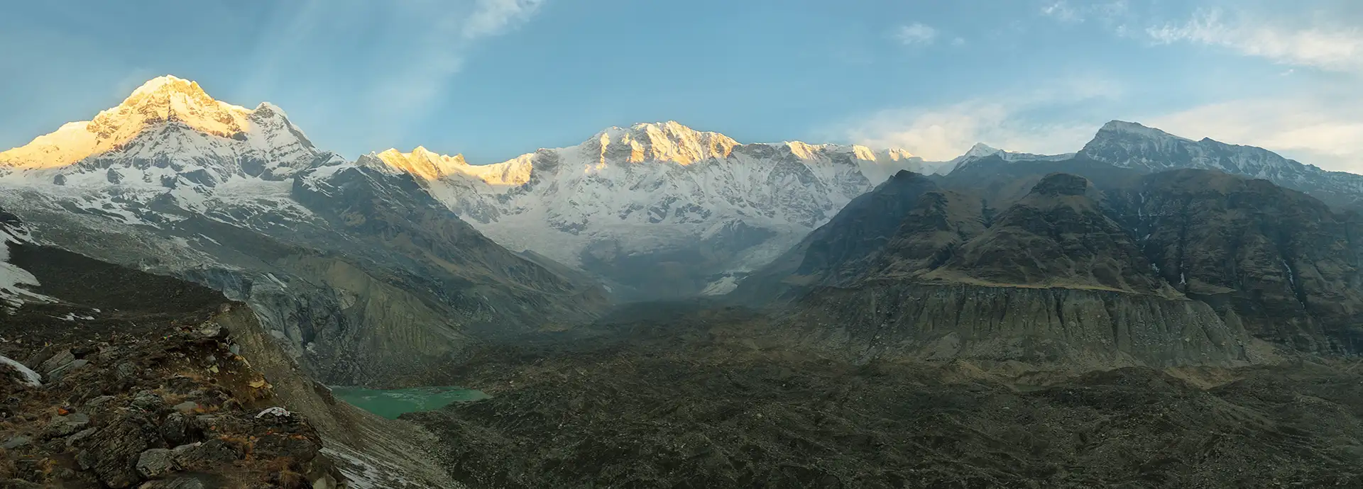
Spending an extra night in Manang means your body gets the time to adjust to the thin air. You can go on side hikes to Gangapurna Lake (3,900m) or nearby viewpoints. Going on hikes to slightly higher points aids acclimatization and offers beautiful scenery.
Day 7 – Manang to Yak Kharka (4,050 m / 13,287 ft)
As you enter the alpine terrain, you reach the 4,000m mark and notice the sparse vegetation. Yak Kharka, which means yak pasture, is a small cluster of lodges en route to Thorong La Pass.
Day 8 – Yak Kharka to Thorong Phedi (4,450 m / 14,600 ft)
Thorong Phedi means the foot of the hill and sits below the pass. Few trekkers continue the trek to High Camo at 4,800m to shorten the next day’s trek., You can rest here as breathing gets harder and nights are freezing.
Day 9 – Thorong Phedi/High Camp to Thorong La Pass (5,416 m / 17,769 ft), then down to Muktinath (3,800 m / 12,467 ft)
Day 9 is the hardest day on the trail. You’ll begin before dawn and climb nearly 1,000m from Phedi to Thorong La. You’ll reach the trek’s highest point, marked by colorful prayer flags. You’ll then descend roughly 1,600m to Muktinath, a sacred temple, the same day.
Day 10 – Muktinath to Jomsom (2,720 m / 8,923 ft)
You’ll drop quickly into the Kali Gandaki Valley after crossing the pass. The oxygen level increases, and you’ll reach the town of Jomsom as you trek through the windy landscape.
Note: Itineraries may vary depending on the trailhead, rest days, or individual pacing, but these elevation milestones represent a standard route.
The Challenge of Thorong La Pass
The Thorong La Pass is the greatest challenge of the Annapurna Circuit. You must wake up around 4:00 AM or earlier, then push to the pass from Thorong Phedi or the High Pass. You’ll reach the summit in the early hours. The summit gets strong winds by midday with rapidly changing weather conditions. You must reach their summit early to avoid the harsh wind.
The climb from Thorong Phedi to Thorong La pass involves about 1,000m in a vertical slope. Each step makes you tired at this high altitude. You should take small, deliberate steps to conserve energy and cope with the thin air.
Reaching Thorong La Pass means you’re standing at 5,416m. The pass is higher than nearly all mountains outside the Himalayas. You can get a panoramic view of parts of Tibet and Mustang. Don’t stay too long here, as the cold and altitude may take a toll on you. The descent to Muktinath at 3,800m is long and demanding. You will climb from 4,500m to 5,416m, then descend to 3,800m all in one day. You’ll experience a dramatic altitude change, testing your knees, endurance, strength, stamina, and mental resilience on the circuit.
Acclimatization and Altitude Sickness
Acclimatization can make all the difference in the Annapurna Circuit. Climbing too quickly exposes you to Acute Mountain Sickness (AMS) risks. This itinerary allows your body to adapt to the thinner air before pushing higher.
A common strategy you can follow is climbing high and sleeping low. You’ll spend an extra day in Manang and hike a few hundred meters above your sleeping point. It stimulates the body and increases the red blood cells to maintain oxygen. A gradual explorer helps your body acclimate while reducing the risk of AMS.
You must recognize the warning signs of altitude sickness in these high-altitude places. Early symptoms include headaches, dizziness, nausea, poor appetite, and tube sleeping. You should stop climbing and rest if you notice any of these symptoms. If these symptoms intensify to severe headaches, vomiting, confusion, or staggering, you must descend immediately.
There is no ultimate prevention of altitude sickness as it can tackle even the fittest trekker. You should climb at a slow and steady pace while hydrating. The traditional route gradually increases altitude, which lets your body adapt naturally. Skipping lower settlements to drive to Manang directly is risky, as your body misses the gradual adjustment and can’t handle higher elevations.
Other practical tips are staying hydrated, avoiding alcohol, and eating enough calories. Dome trekkers take Diamox to aid with acclimatization after consulting their doctors.
Factors Affecting Annapurna Circuit Trek Height
While Thorong La Pass at 5,416m is the literal high point of the Annapurna Circuit, the elevations you experience can vary depending on several factors.
Trek Start and End Points: The classic circuit route begins at Besisahar at 760m. You can start further along the trail as the road stretches to Jagat and Chame. Your starting point influences how gradually you’ll ascend. Don’t skip too far ahead by vehicle; it can strain your body if you haven’t acclimatized appropriately.
Side Trips: You can go on an optional excursion to add extra altitude and challenge. Hiking to Tilicho Lake is a popular option. Tilicho Lake at 4,919m is the highest lake in the world. It typically takes three days from Manang and brings you close to Thorong La’s elevation. You can also hike to Ice Lake at 4,600m above Manang. The Ice Lake hike is an excellent acclimatization hike offering beautiful views.
Trekking Direction: Most trekkers go counter-clockwise. Approaching Thorong La from the east, the Manang side, allows for a gradual ascent. The western side, from Muktinath, is much steeper. Attempting the circuit clockwise requires climbing from 3,800 m to 5,416 m daily, which is very dangerous. The counter-clockwise route spreads the elevation gain over several days and reduces the risk of altitude sickness.
Conclusion
The Annapurna Circuit’s dramatic elevation changes make it both challenging and fun. You’ll go from humid lowlands to high mountain passes. You need proper preparation, a steady pace, and a humble approach to finish the trek successfully. It’s one of the ultimate trekking challenges with great rewards.