
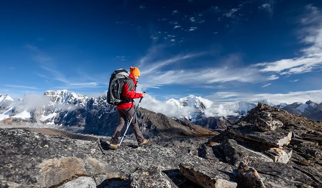
This Everest Base Camp trek guides you through a day-by-day breakdown of the trek. This detailed Everest Base Camp Trek Itinerary includes the 12 to 14-day round trip from Lukla to the base camp. We recognize the Everest Base Camp trek as one of the most popular treks in the world. The beautiful views, challenging trails, and the feeling of being near the world’s highest peak make the trek worth it. Peregrine Treks and Tours offers a carefully organized, pleasant trekking experience. We also included advice on accommodation, rest days, permits, trekking season, and optional side trips. This guide explains everything you can expect from the Everest Base Camp trek.
Key Considerations for Your Trek
Acclimatization and Pace
The Everest Base Camp trek is entirely at high altitudes, so giving your body time to adjust is essential. This EBC guide includes rest stops in Namche and Dingboche. You should go slow, take it easy on the climbs, and don’t rush. Staying hydrated helps. Eat light and get good sleep. If you feel dizzy, nauseous, or have a headache, let your guide know immediately. Listen to your body; pacing yourself well is the best way to avoid altitude sickness.
Flexibility and Weather
The weather in the mountains is hard to predict, and delays can happen. Icy trials or cancelled flights are possible. You can add buffer days to your plan for any potential delays. Peregrine Treks and Tours can include optional rest days. It’s better to be flexible and arrive late than risk your health.
Detailed Everest Base Camp Trek Itinerary
Day 1: Land in Lukla and trek to Phakding (2,610m)
You’ll begin your trip with a scenic flight to Lukla on a small STOL aircraft (2,860 m). You will either depart from Kathmandu or Ramechhap according to the air traffic.
You start your hike after landing in Lukla and briefing eight team members. You will travel about 8 km to Phakding (2,610 m) for 3 to 4 hours. The route passes through pine forests, several suspension bridges, and small Sherpa villages along the Dudh Koshi River. It’s mostly downhill, but you may still feel the effects of altitude. Walk carefully, keep your backpack light, and consider hiring a porter.
Today, you won’t gain any altitude. You descend for about 250m. In Phakding, you’ll stay in a teahouse with simple accommodations and shared bathrooms. Meals are hearty and warm, usually Daal Bhaat, noodles, or soup. The views from both the flight and the trail set a beautiful tone for the adventure ahead.
- Distance: 35-minute flight, then 8km to Phakding from Lukla
- Walking Time: About 3 to 4 hours.
- Highlights: Scenic views of the mountains while on board to Lukla, pine forests and streams, Sherpa villages, and suspension bridges
- Accommodation: Phakding
Physical Challenges: The path mostly goes downhill, but you might feel the altitude. - Acclimatization: Altitude will not change drastically, with about 250m lost.
Day 2: Phakding (2,610m) to Namche Bazaar (3,440m)
Today, you cover around 9 to 10 km over 5 to 6 hours. The trail passes through scenic villages like Monjo and Jorsalle and crosses several suspension bridges over the Dudh Koshi River.
You will go through the Sagarmatha National Park in Monjo. You might catch your first glimpse of Mt. Everest if the skies are clear. You climb the final stretch through the rhododendron forest leading into Namche.
The altitude gain is significant, rising from 2,610 m to 3,440 m. Walk at a steady pace and take short breaks. You will reach Namche by the afternoon. You’ll stay in a teahouse with better amenities than in Phakding. This bustling Sherpa town offers markets, cafes, and beautiful mountain views.
- Distance: About 9 to 10 km.
- Walking Time: ~5 to 6 hours
- Highlights: Glimpse of Mt. Everest. Pass villages like Monjo and Jorsalle. Cross several suspension bridges and go through Sagarmatha National Park.
- Accommodation: Namche Bazaar
- Physical Challenges: Significant altitude gain from 2010m to 3440m. A couple of hours of uphill. Be sure to walk comfortably and take short breaks in between.
- Acclimatization: Resting in Namche Bazar for an extra day to adjust your body to the altitude is better.
Day 3: Acclimatization Day in Namche Bazaar
Today is acclimatization day. You can take short hikes around town, such as to the Sagarmatha National Park headquarters or the Everest View Hotel at 3,880 meters, which offers stunning views of Everest, Lhotse, and Ama Dablam. If time allows, visit the Sherpa Culture Museum or browse the weekly market. These walks usually take 2 to 3 hours and help your body adjust to the higher altitude. Since the air is thinner here, keep your hikes light and steady. Stay at the same teahouse or try a different one in town. Eat well, drink plenty of water, and take it easy to support proper acclimatization.
- Walking time: 2–3 hours for short walks.
- Highlights: Excellent views of Everest, Lhotse, and Ama Dablam.
- Accommodation: Another night in Namche Bazaar.
- Physical Challenges: The air is thinner here, so keep your hikes short and easy.
- Acclimatization: The hike to the viewpoint involves about 400m of climbing, but it goes slowly. Drink plenty of water and eat well to help your body get used to the altitude.
Day 4: Namche Bazaar to Tengboche (3,870m)
Today’s trek from Namche Bazaar to Tengboche covers about 10 km and takes 4 to 5 hours. The trail steadily gains altitude as you pass through Sherpa villages and pine and rhododendron forests.
Tengboche is home to Dawa Choling Gompa, the largest monastery in the Khumbu. You might witness monks in prayer in the afternoon here. Tengboche offers beautiful views of Everest, Ama Dablam, and Nuptse. The final climb above Debuche is steep and tiring due to the thinning air at nearly 4,000 meters.
You’ll stay in simple wooden lodges with mountain views and available hot showers. Stroll, drink plenty of water, and eat well to support your body’s adjustment to the higher elevation.
- Route & Distance: Around 10 km.
- Walking Time: About 4 to 5 hours
- Highlights: Tengboche’s Dawa Choling Gompa has fantastic views of Everest, Ama Dablam, and Nuptse.
- Accommodation: STengboche in wooden cabins with views of the mountains.
- Physical Challenges: Altitude of almost 4,000 m, thinner air, and steep trails above Debuche.
- Acclimatization: Tengboche helps with gradual acclimatization. Stroll to avoid altitude sickness. Stay hydrated and eat well.
Day 5: Tengboche (3,870m) to Dingboche (4,360m)
Today’s trek covers 10 to 11 km and takes about 5 to 6 hours. You’ll descend into the Imja Khola Valley before climbing steadily up to Dingboche, a high-altitude village at 4,360 meters. You get clear views of the mountains, especially of Ama Dablam, Cholatse, and Taboche. Dingboche is a broad meadow with giant peaks surrounding it.
Lodges here are basic but comfortable, usually offering private rooms with shared bathrooms. The final climb into the village can feel tough due to the thin air, so take your time and listen to your body. Most trekkers spend an extra night here for acclimatization.
- Route & Distance: 10 km to 11 km.
- Walking Time: About 5 to 6 hours
- Highlights: Walk to Imja Khola Valley, which has clear views of Ama Dablam, Cholatse, and Taboche.
- Accommodation: Basic lodges with private rooms and shared bathrooms.
- Physical Challenges: Extreme altitude at 4,360m. The final steps to Dingboche are uphill. Shortness of breath and tiredness are common. Take it slow.
- Acclimatization: Stay an extra day to rest. Drink plenty of water and avoid alcohol.
Day 6: Acclimatization Day at Dingboche
Today is a rest and acclimatization day in Dingboche. You can hike a 4–5-hour hike to Nangkartshang Peak (around 5,000m). Nangkartshang Peak offers stunning views of Ama Dablam and Makalu.
Return to the village during midday for lunch, explore the town, and relax. Spend another night at your current teahouse or switch if you’d like. At this altitude, it’s normal to feel tired or lose your appetite, so listen to your body. Stay hydrated, eat well, and move lightly to help adjust to the thinner air.
- Route & Distance: Rest and hike to Nangkartshang hill.
- Walking Time: 4–5 hours for short hikes.
- Highlights: Nangkartshang at 5,000m offers views of mountains like Makalu and Ama Dablam.
- Accommodation: You can spend another night at the same teahouse.
- Physical Challenges: Rest and adapt your body to the altitude. Losing appetite and feeling sleepy is common.
- Acclimatization: Drink water and eat carbs. Do light exercises, and don’t rush your body.
Day 7: Dingboche (4,360m) to Lobuche (4,910m)
Today’s trek is from Dingboche to Lobuche. It covers about 7 to 8 km and takes 4 to 5 hours. The trail climbs steadily through rocky terrain and moraine fields. You will pass herds of yaks and stone prayer cairns along the way. At Thukla Pass, you’ll see memorials to climbers lost on Everest. You might catch your first full view of Everest from the ridges above Lobuche.
Lodges in Lobuche are very basic, often cold, with limited hot water. At nearly 5,000m, the thin air makes even short climbs tiring. Go slow, rest usually, and drink plenty of water as you adjust to the higher altitude.
- Route & Distance: 7 km to 8 km.
- Walking Time: About 4 to 5 hours
- Highlights: You will pass moraine and rocky paths, prayer stone piles, and herds of yaks. Memorials for the climbers who fell from Khumbu Icefall at Thukla Pass. Full view of Mount Everest from the ridges above the village.
- Accommodation: Lodges are simple and cold with basic heating setups in Lobuche. Hot water is not readily available.
- Physical Challenges: Almost 5000m, oxygen levels are extremely low, and the air is thin. A few steps can make you out of breath. You will have to walk steep trails near the last viewpoint.
- Acclimatization: You have entered land above 4000, and elevation will continue to rise daily. Stroll, rest well, and stay warm and hydrated.
Day 8: Lobuche (4,910m) to Everest Base Camp (5,364m) and back to Gorak Shep (5,184m)
Today is the big day. You’ll trek 3 km from Lobuche to Gorak Shep in the morning, then hike 5 km round trip to Everest Base Camp and back. The total walking time is around 7 to 9 hours. The trail follows a glacial moraine with incredible views. You’ll see the Khumbu Icefall from the trail. Colorful expedition tents decorate the Everest Base Camp during the climbing season. You will stand at the Everest Base Camp, your destination.
After reaching Base Camp, you return to Gorak Shep (5,184 m) for the night. The altitude and cold make this the toughest day, with thin air, slippery terrain, and freezing wind. Sleep may be difficult, but the sense of achievement is unmatched. Go slow, stay warm, and savor the moment.
- Route & Distance: Hike from Lobuche 3km to Gorak Shep, then to the Everest Base Camp, and return to Gorak Shep, 5km for the round trip.
- Walking Time: About 7 to 9 hours total
- Highlights: Hike from Lobuche to Gorak Shep, then continue to Everest Base Camp along a rocky glacial trail. See the Khumbu Icefall and, during climbing season, the bright tents. Return to Gorak Shep to sleep at high altitude.
- Accommodation: You will return to Gorak Shep and stay the night there. You will be sleeping at 5,184m above sea level.
- Physical Challenges: You will trek from 4,910 m to 5,364m on slippery glacial rubble, with the air especially thin. The wind at Base Camp is freezing.
- Acclimatization: You will be sleeping at the summit altitude. Just a night at Gorak Shep can push your body to its limit. Just enjoy your accomplishment.
Day 9: Kala Patthar (5,545m) Sunrise and Trek to Pheriche (4,371m)
You’ll begin your pre-dawn hike to Kala Patthar, the trek’s highest point. Hiking to Kala Patthar and then to Pheriche covers about 13km. The first 3 to 4 hours are a cold, steep climb in the dark. You can enjoy the sunrise view over Everest, Lhotse, Nuptse, and Ama Dablam from the summit. After taking in the views, you’ll walk back to Gorak Shep. After packing and having breakfast, you begin a long descent to Pheriche, which takes about 7 to 8 hours.
The trail can be challenging on the knees, so walk carefully. At nearly 4,200 meters, Pheriche feels easier to breathe in. Though the hardest altitudes are behind you, walking steadily and staying hydrated is still best.
- Route & Distance: Hike up towards Kala Patthar, then down to Pheriche, covering a distance of 13km.
- Walking Time: About 7 to 8 hours.
- Highlights: 3 to 4 hours to Kala Patthar with sunrise views of mountains like Everest, Lhotse, Nuptse, Ama Dablam, and other peaks in view.
- Accommodation: You will be staying in Pheriche at a teahouse
- Physical Challenges: Almost 360m altitude gain from Gorak Shep to Kala Patthar. The morning will be cold, and the descent will be demanding and hard on the legs.
- Acclimatization: The altitude will drop today, making it easier.
Day 10: Pheriche (4,371m) to Namche Bazaar (3,440m)
The trek from Pheriche to Namche Bazaar covers about 22 to 23 kilometers in 7 to 8 hours. You trek through the familiar paths, passing Tengboche and its iconic monastery. You’ll cross the Hillary Suspension Bridge again, and as you descend, the forests become greener and the air more prosperous. The village of Kyangjuma feels livelier on the way back. While the descent is easier than the uphill days, it can still be tough on the knees. The drop in altitude will help you feel stronger, improve your appetite, and allow for better sleep. You’ll stay in Namche Bazaar again, just like before.
- Route & Distance: ~22 to 23 km.
- Walking Time: Between 7 and 8 hours.
- Highlights: As altitude drops, you’ll pass the Tengboche Monastery, crossing the Hillary Suspension Bridge, enjoying greener forests and thicker air.
- Accommodation: Stay in Namche Bazar, as we did the previous time.
- Physical Challenges: Descending may be tricky on the legs, but regardless, it is easier than the earlier days of ascending. Altitude drop will make you feel better. Hydrate and rest well.
- Acclimatization: Altitude drop will improve your appetite and sleep.
Day 11: Namche Bazaar to Lukla (2,860m)
You will hike back to where it all began in Lukla, covering about 21 kilometers in 7 to 8 hours. This final stretch of the Everest Base Camp trek is downhill, primarily with warmer temperatures and lush vegetation. As you reach Lukla, the small airstrip marks the end of your journey and offers a moment to reflect. You will spend the night in Lukla celebrating with a well-earned meal. Although the descent is easier, it can still be tiring, so remember to rest and stay hydrated. At 2,860 meters, the denser air will help you feel stronger and more energized.
- Route & Distance: About 21km.
- Walking Time: Hiking down to Lukla will take 7 to 8 hours.
- Highlights: Trails are mostly downhill, and the temperature is warm, with fields full of vegetation.
- Accommodation: Celebration to mark the end of your trek in Lukla. Spend a night there and enjoy a congratulatory meal.
- Physical Challenges: Descending long paths may take a toll on your body.
- Acclimatization: You will be at an altitude of 2,860 m and feel stronger as the air is denser.
Day 12: Fly from Lukla or Manthali to Kathmandu
Today, you will fly directly from Lukla to Kathmandu or from Lukla to Manthali Airport, followed by a 4 to 5-hour drive to Kathmandu. The flight from Lukla to Kathmandu takes about 30 to 35 minutes, while the Lukla to Manthali flight is around 20 minutes. You’ll enjoy beautiful mountain views along the way, and the drive from Manthali to Kathmandu passes through hills and rivers.
Your trek ends when you return to Kathmandu, where you can relax, explore, and enjoy various meals and a comfortable bed. Lukla can be cold, and flights depend on weather conditions. The drive from Manthali may feel long and bumpy.
- Route: Flight from Lukla to Kathmandu directly, or Lukla to Manthali Airport and then to Kathmandu
- Flight Time: 30 to 35 minutes flight from Lukla to Kathmandu. 20 20-minute flight from Lukla to Manthali, then 4 to 5 hours’ drive from Manthali to Kathmandu.
- Highlights: Beautiful views of the mountains. The drive from Manthali to Kathmandu will pass through many hills and rivers. You have officially completed your trek once you are back in Kathmandu.
- Accommodation: Explore and rest in Kathmandu.
- Challenges: Lukla may be cold. Flight departure depends on the weather, and the drive may feel long with bumpy roads.
- Acclimatization: The Trek has ended, and you will have no more altitude problems. Enjoy.
Packing Essentials
Pack Light, Stay Warm, Be Ready: Essentials for Teahouse Trekking
- Clothing: Base layering made with synthetic fabric, down jackets, waterproof clothing, and small items like a warm hat and gloves.
- Footwear: Comfortable, nice trekking boots, socks, and gaiters
- Gear: A 4-season sleeping bag, sun protection, water purifier, trekking poles, and headlamps.
- Documents: Passport, permits, ID photos, Nepal visa, and travel insurance documents.
- Additional essentials: Prescribed medicines and first aid kit, energy bars, toiletries, power bank, sanitizer, camera, etc.
Double-check your backpack to make sure you have everything you need. Don’t pack too much. Rent items like sleeping bags and a down jacket to lose weight while leaving Nepal. Porters can carry 20kg, so pack accordingly.
Food and Lodging on the Trail
Lodges serve basic fueling food. They are full of nutrients and energize your body. On the trail, you will find common foods like Dal Bhaat, momo, thukpa, and pasta. When you start getting to the higher trails, lodges may not serve vegetables as they are hard to grow. Drink hot liquids like butter tea or tea with lemon, honey, and water.
Teahouses double as accommodation. Most of these are family-owned. You have to pay for a bed, not a room, so you may have to share rooms. Bathrooms are typically shared, and toilets are squat-style. Higher altitudes have even fewer facilities and amenities. You will share tables with fellow trekkers and pay to charge your phone and even for WIFI.
Guides and Porters
An experienced guide plans the trek well, shares knowledge of the local communities and history, and ensures everyone is safe. They can even detect the early signs of altitude sickness with their knowledge.
Porters carry your load. They are allowed to have 20 a maximum weight above 5000m. Hiring a porter means you can trek with a light backpack with essentials. Peregrine Treks and Tours offer professional, trained guides and dependable porters to enhance your trekking experience. Tipping your porters and guides according to your satisfaction with their work is also advised.
Permits and Regulations
You need two permits: Sagarmatha National Park and Khumbu Pasang Lhamu Rural Municipality. If you are starting your trek from Jiri, you will also need a Gauri Shankar Conservation Area Permit (GCAP). To avoid possible hassles, carry extra ID photos and photocopies of all essential documents. Peregrine Treks arranges all the permits before the trek begins.
Best Trekking Seasons
Here is some brief information on different seasons for trekking:
- Spring (March-May): Blooming flowers, good weather, and clear views make it the most preferred season.
- Autumn (September–November): Clear views, colder weather with dry trails, a good trekking season
- Monsoon season (June–August): Heavy rain, wet trails, leeches everywhere, foggy atmosphere, flooded rivers. It’s hard to trek, so it’s not a well-visited season.
- Winter (December–February): The weather in the trails is already cold, making it freezing, with snow-covered trails, and making it hard to trek.
Spring and autumn are more popular than monsoon and winter. Peace-seeking experienced trekkers can walk the trail even in monsoon and winter. Popular seasons are also more expensive than other seasons. But they are also objectively easier and prettier to walk in. So, choose accordingly.
Budgeting Tips
Here are a few budgeting tips for your trip to save some money:
- Meals & Drinks: Meals are pricier on the trekking trails. The transportation of food and other supplies is hard, making every meal a result of hard work. You can share platters with other trekkers to save money. Before the trek starts, budget for all your meals, including snacks and drinks, and carry the cash accordingly.
- Cash: Very few ATMs are operating in the high trails. They are only in Namche and Lukla, but they are not reliable. Cash is the only way to make transactions, so carry enough extra to avoid problems. Carry Nepali rupees and prepare well.
- Insurance: Make sure to purchase a nice travel insurance plan. Choose the one that covers high-altitude trekking and helicopter rescue.
- Sharing Gear: You can reduce weight and cost by sharing stuff like a down jacket and a first aid kit with your friend.
- Tips & Extras: You can tip the service providers. Charging electronics and hot showers cost you money. It is essential to factor in these extra expenses while budgeting.
Physical Preparation
Train your body at least 2 months in advance. Work on your legs and core strength. Hike up a hill or stairs with a weighted backpack. Exercise daily; you can swim, run, cycle, etc. Ensure your body is physically fit and able to trek multiple days. You will also have to practice breathing exercises to improve your lungs.
Precautions for Altitude Sickness
Your body may get Acute Mountain Sickness (AMS) above 3000m. Headache, nausea, fatigue, and dizziness are common symptoms of altitude sickness. To prevent:
- Walk at a comfortable pace. The itinerary includes rest days and ensures the ascent is gradual and steady.
- Stay hydrated and urinate frequently.
- Eat lots of carbs and frequent but light meals.
- Drink lots of liquid, but avoid any alcohol and sedating drugs.
- Rest and adjust well on acclimation days.
- Listen to your body. If it cannot handle the altitude, descend immediately. Severe fatigue and headaches may be some signs. If the symptoms are mild, focus on getting plenty of rest.
- If prescribed and advised by the guide, take acetazolamide.
Popular Itinerary Variations
Gokyo Lakes Extension
The Gokyo Lakes trek is a scenic extension to the Everest Base Camp route, adding about 3–4 days. Instead of descending after Dingboche, trekkers can detour west from Namche into the quieter Gokyo Valley. Highlights include the Gokyo Lakes, a climb up Gokyo Ri (5,357m) for views of Everest and Cho Oyu, and a crossing of Nepal’s largest glacier, Ngozumpa. It’s a perfect option for those seeking fewer crowds and a touch of extra adventure.
Three Passes Trek (High Passes)
The Three Passes trek is an additional 18 to 21 days. This trek crosses Renjo La (5,360m), Cho La (5,420m), and Kongma La (5,535m).
The trail is remote, so an extra permit and a guide are required. This section is demanding and best suited for trekkers who are well-acclimatized and confident at high altitudes. The loop feels wild and raw, with fewer tea houses, vast mountain views, and sweeping glacial valleys. If you have the time, the fitness, and a sense of adventure, it’s worth exploring.
Jiri to Everest Base Camp
The Jiri route is the traditional and longer route. Your extension is from 19 to 20 days. The route allows better acclimatization. You will pass villages like Junbesi and Sete. You will join other trekkers at the main trail at Namche. Trekkers wanting longer experiences in the wilderness can choose this remote, peaceful, and beautiful trail.
Ready to Trek?
We hope this Everest Base Camp Trek Itinerary gives you a clear vision for your trek. We ensure your trek finishes with the best possible experience. We choose experienced guides, reliable porters, and established teahouses. The itinerary will allow your body to adjust and enjoy the trek. Whatever route you select, you will pass through Sherpa villages, cross suspension bridges, and finally complete the trek at the foot of the highest peak.
Tick the checkbox for your bucket list with Peregrine Treks and Tours. Experience the Everest Base Camp trek with expert guidance, unmatched support, and memories that last a lifetime.